File:Map of the north Western frontier of British India, including the protected sikh States, Lahore, Cashmier, Cabul, Hirat, Candahar, Skikarpore and Bhawalpore, together with Sinde and Rajpootana, the Indus... - btv1b52513643z (1 of 2).jpg

Size of this preview: 693 × 599 pixels. Other resolutions: 278 × 240 pixels | 555 × 480 pixels | 888 × 768 pixels | 1,184 × 1,024 pixels | 2,368 × 2,048 pixels | 14,531 × 12,567 pixels.
Original file (14,531 × 12,567 pixels, file size: 30.74 MB, MIME type: image/jpeg)
Captions
Captions
Add a one-line explanation of what this file represents
Summary edit
| Warning | The original file is very high-resolution. It might not load properly or could cause your browser to freeze when opened at full size. |
|---|
| Author |
Tassin, Jean-Baptiste (1800-1868). Auteur du texte |
||||||||||||||||||||||||||
| Title |
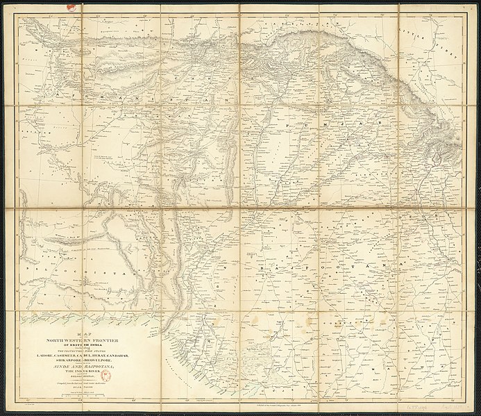
Map of the north Western frontier of British India, including the protected sikh States, Lahore, Cashmier, Cabul, Hirat, Candahar, Skikarpore and Bhawalpore, together with Sinde and Rajpootana, the Indus river and part of Beloochistan / compiled... by J. B. Tassin |
||||||||||||||||||||||||||
| Description |
Français : Sujet : Indienne, Péninsule -- Nord-Ouest -- Frontière
Langue : anglais Éditeur : at the oriental lithographic press (Calcutta) |
||||||||||||||||||||||||||
| Date | 1838 | ||||||||||||||||||||||||||
| Dimensions | height: 78 cm (30.7 in); width: 88 cm (34.6 in) | ||||||||||||||||||||||||||
| Collection |
|
||||||||||||||||||||||||||
| References |
Français : Notice du catalogue : http://catalogue.bnf.fr/ark:/12148/cb40744681z |
||||||||||||||||||||||||||
| Source/Photographer |
Français : Bibliothèque nationale de France, département Cartes et plans, GE FF-13274 (CARTE)
Bibliothèque nationale de France (1/2) |
||||||||||||||||||||||||||
| Permission (Reusing this file) |
|
||||||||||||||||||||||||||

.jpg&action=edit§ion=1)
File history
Click on a date/time to view the file as it appeared at that time.
| Date/Time | Thumbnail | Dimensions | User | Comment | |
|---|---|---|---|---|---|
| current | 17:22, 19 August 2022 | | 14,531 × 12,567 (30.74 MB) | Gzen92Bot (talk | contribs) | Gallica btv1b52513643z |
You cannot overwrite this file.
File usage on Commons
The following page uses this file:
.jpg)
.jpg&oldid=863999677)