File:Map of the surveyed part of the territory of Michigan 1825.jpg

Size of this preview: 389 × 599 pixels. Other resolutions: 156 × 240 pixels | 312 × 480 pixels | 499 × 768 pixels | 665 × 1,024 pixels | 1,330 × 2,048 pixels | 8,298 × 12,772 pixels.
Original file (8,298 × 12,772 pixels, file size: 27.75 MB, MIME type: image/jpeg)
Captions
Captions
Add a one-line explanation of what this file represents
Summary
edit
| Warning | The original file is very high-resolution. It might not load properly or could cause your browser to freeze when opened at full size. |
|---|
| Description |
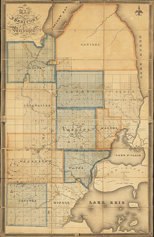
English: Map of the surveyed part of the territory of Michigan / by O. Risdon ; engraved by Rawdon, Clark & Co.
Originally published: [Albany, N.Y.] : [O. Risdon], 1825. Scan of a map in the collection of the Michigan State University Map Library. MSU Libraries catalog record: http://catalog.lib.msu.edu/record=b12049216~S39a |
| Date | |
| Source | https://www.lib.msu.edu/branches/map/MiJPEGS/843-c-A-1825/ |
| Author | Orange Risdon. Engraved by Rawdon, Clark & Co. |
Licensing
edit
This media file is in the public domain in the United States. This applies to U.S. works where the copyright has expired, often because its first publication occurred prior to January 1, 1929, and if not then due to lack of notice or renewal. See this page for further explanation.
|
 | |
 |
This image might not be in the public domain outside of the United States; this especially applies in the countries and areas that do not apply the rule of the shorter term for US works, such as Canada, Mainland China (not Hong Kong or Macao), Germany, Mexico, and Switzerland. The creator and year of publication are essential information and must be provided. See Wikipedia:Public domain and Wikipedia:Copyrights for more details.
|
File history
Click on a date/time to view the file as it appeared at that time.
| Date/Time | Thumbnail | Dimensions | User | Comment | |
|---|---|---|---|---|---|
| current | 16:00, 7 October 2016 | | 8,298 × 12,772 (27.75 MB) | TimK MSI (talk | contribs) | {{Information |Description ={{en|1=Map of the surveyed part of the territory of Michigan / by O. Risdon ; engraved by Rawdon, Clark & Co. Originally published: [Albany, N.Y.] : [O. Risdon], 1825. Scan of a map in the collection of the Michigan Sta... |
You cannot overwrite this file.
File usage on Commons
There are no pages that use this file.
File usage on other wikis
The following other wikis use this file:
- Usage on en.wikipedia.org