File:Map of world highlighting Antarctica & capes.png
No higher resolution available.
Map_of_world_highlighting_Antarctica_&_capes.png (300 × 153 pixels, file size: 18 KB, MIME type: image/png)
Captions
Captions
Add a one-line explanation of what this file represents
Summary
edit
| Description |
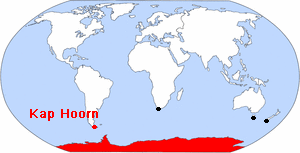
Deutsch: Weltkarte: Rot markiert sind die Antarktis und Kap Hoorn, schwarz markiert sind (von West nach Ost) das Kap Agulhas in Südafrika, das Südostkap in Tasmanien (Australien) und das Südwestkap an der Südspitze von Neuseeland
English: Map of the world: Antarctica and Cape Horn are marked in red; Cape Agulhas (South Africa), South East Cape (Tasmania/ Australia) and South West Cape (southern-most point of New Zealand) are marked in black |
| Source | Originally from the CIA Factbook, modified to highlight Antarctica by Wapcaplet on the en.wikipedia, description page is/was here; further modified to mark the capes and add a label by Ibn Battuta |
| Author | Original from the CIA Factbook, original uploader was Wapcaplet at en.wikipedia, uploader to Wikimedia Commons was Ibn Battuta |
Licensing
edit
This image is in the public domain because it contains materials that originally came from the United States Central Intelligence Agency's World Factbook.
|
 |
Original upload log
edit
(All user names refer to en.wikipedia)
- 2003-08-16 15:13 Wapcaplet 300×153×8 (11586 bytes) Originally from the [http://www.cia.gov/cia/publications/factbook/ CIA Factbook], modified to highlight various regions.
File history
Click on a date/time to view the file as it appeared at that time.
| Date/Time | Thumbnail | Dimensions | User | Comment | |
|---|---|---|---|---|---|
| current | 00:51, 25 November 2006 | | 300 × 153 (18 KB) | Ibn Battuta (talk | contribs) | {{Information |Description={{de|Weltkarte: Rot markiert sind die Antarktis und Kap Hoorn, schwarz markiert sind (von West nach Ost) das Kap Agulhas in Südafrika, das Südostkap in |
You cannot overwrite this file.
File usage on Commons
There are no pages that use this file.
File usage on other wikis
The following other wikis use this file:
- Usage on de.wikipedia.org