File:Mapa ARGENTINA frontera.png
No higher resolution available.
Mapa_ARGENTINA_frontera.png (377 × 523 pixels, file size: 59 KB, MIME type: image/png)
Captions
Captions
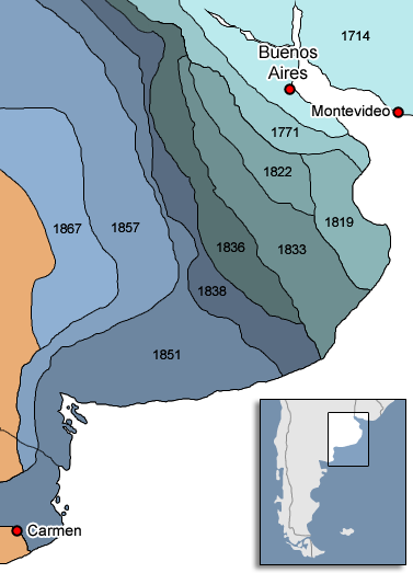
Mapa de la frontera de la provincia de Buenos Aires con la nación mapuche y otros pueblos originarios.
== Summary

==
| Description | mapa de la frontera de la provincia de buenos aires con la nacion mapuche y otros pueblos originarios |
| Date | |
| Source | Own work |
| Author | pruxo |

|
This historical map image could be re-created using vector graphics as an SVG file. This has several advantages; see Commons:Media for cleanup for more information. If an SVG form of this image is available, please upload it and afterwards replace this template with
{{vector version available|new image name}}.
It is recommended to name the SVG file “Mapa ARGENTINA frontera.svg”—then the template Vector version available (or Vva) does not need the new image name parameter. |
Licensing
edit
I, the copyright holder of this work, hereby publish it under the following licenses:

|
Permission is granted to copy, distribute and/or modify this document under the terms of the GNU Free Documentation License, Version 1.2 or any later version published by the Free Software Foundation; with no Invariant Sections, no Front-Cover Texts, and no Back-Cover Texts. A copy of the license is included in the section entitled GNU Free Documentation License. |
| This file is licensed under the Creative Commons Attribution-Share Alike 3.0 Unported license. | ||
| ||
| This licensing tag was added to this file as part of the GFDL licensing update. |
This file is licensed under the Creative Commons Attribution 2.5 Generic license.
- You are free:
- to share – to copy, distribute and transmit the work
- to remix – to adapt the work
- Under the following conditions:
- attribution – You must give appropriate credit, provide a link to the license, and indicate if changes were made. You may do so in any reasonable manner, but not in any way that suggests the licensor endorses you or your use.
You may select the license of your choice.
File history
Click on a date/time to view the file as it appeared at that time.
| Date/Time | Thumbnail | Dimensions | User | Comment | |
|---|---|---|---|---|---|
| current | 18:24, 9 May 2011 | | 377 × 523 (59 KB) | Ben Robbins (talk | contribs) | Cleaned up edges, made clearer, made alpha, added location map |
| 14:07, 28 May 2007 |  | 377 × 523 (45 KB) | Pruxo (talk | contribs) | {{Information |Description=mapa de la frontera de la provincia de buenos aires con la nacion mapuche y otros pueblos originarios |Source=trabajo propio |Date=2007 |Author=pruxo |Permission= |other_versions= }} |
You cannot overwrite this file.
File usage on Commons
There are no pages that use this file.
File usage on other wikis
The following other wikis use this file:
- Usage on ar.wikipedia.org
- Usage on ast.wikipedia.org
- Usage on en.wikipedia.org
- Usage on es.wikipedia.org
- Adolfo Alsina
- Zanja de Alsina
- Historia del Ejército Argentino
- Disputa de la Patagonia Oriental, Tierra del Fuego y el estrecho de Magallanes
- Comandancia de Patagones
- Campañas previas a la Conquista del Desierto
- Las Bruscas
- Francisco Hermógenes Ramos Mejía
- José Luis Molina (gaucho)
- Fernando Alfaro Maciel
- Ramón Lara
- Ancafilú
- Fuerte de Salto
- Guardia Puesto de López
- Guardia del Monte
- Guardia del Juncal
- Fortín Navarro
- Usage on fa.wikipedia.org
- Usage on fr.wikipedia.org
- Usage on nl.wikipedia.org
- Usage on ru.wikipedia.org
- Usage on uk.wikipedia.org
- Usage on www.wikidata.org
- Usage on zh.wikipedia.org