File:Mapa Imperio romano Aureliano siglo III d.C.png
Original file (3,000 × 1,856 pixels, file size: 7.68 MB, MIME type: image/png)
Captions
Captions
Summary edit
| Description |
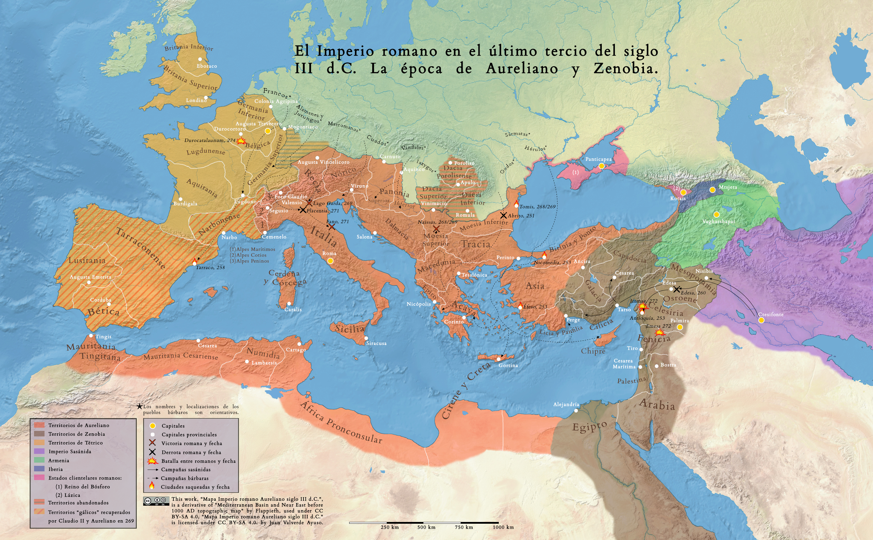
Español: Mapa con correcciones realizadas:
- "Alpes conios" sustituido por la expresión correcta "Alpes Peninos" - Añadida una escala de distancia - Pequeñas correcciones de localizaciones exactas de ciudades y de fronteras. Bibliografía utilizada para realizar el mapa: DOWNEY, G., “Aurelian's Victory over Zenobia at Immae, A.D. 272”, Transactions and Proceedings of the American Philological Association, nº 81 (1950), pp. 57-68. DRINKWATER, J. F., The Gallic Empire: Separatism and Continuity in the North-Western Provinces of the Roman Empire A.D. 260-274. Historia. Einzelschriften, Vol. 52, Stuttgart: Steiner Verlag Wiesbaden, 1987. SAUNDERS, Randall T., “Aurelian's "Two" Iuthungian Wars”, Historia: Zeitschrift für Alte Geschichte, 1992, Vol. 41, nº 3, pp. 311-327. SOUTHERN, Patricia, The Roman empire from Severus to Constantine, Londres: Routledge, 2001. WATSON, Alaric, Aurelian and the Third Century, Londres: Routlegde, 1999. "The Mediterranean in 271 (the Crisis of the Third Century)", mapa realizado por Ian Mladjov, disponible en sites.google.com/a/umich.edu/imladjov/maps Las localizaciones de los pueblos bárbaros, así como sus denominaciones, son orientativas. Por otro lado, sus localizaciones muestran donde se encontraban en el momento de penetrar o atacar las fronteras del Imperio romano, no que fueran originarios de dichos territorios. |
| Date | |
| Source | https://www.flickr.com/photos/192269415@N02/51125470889/ |
| Author | historiaromanaantigua |
Licensing edit
- You are free:
- to share – to copy, distribute and transmit the work
- to remix – to adapt the work
- Under the following conditions:
- attribution – You must give appropriate credit, provide a link to the license, and indicate if changes were made. You may do so in any reasonable manner, but not in any way that suggests the licensor endorses you or your use.
- share alike – If you remix, transform, or build upon the material, you must distribute your contributions under the same or compatible license as the original.
| This image was originally posted to Flickr by historiaromanaantigua at https://flickr.com/photos/192269415@N02/51125470889. It was reviewed on 14 May 2021 by FlickreviewR 2 and was confirmed to be licensed under the terms of the cc-by-sa-2.0. |
File history
Click on a date/time to view the file as it appeared at that time.
| Date/Time | Thumbnail | Dimensions | User | Comment | |
|---|---|---|---|---|---|
| current | 19:47, 14 May 2021 | | 3,000 × 1,856 (7.68 MB) | Ser Amantio di Nicolao (talk | contribs) | Uploaded a work by historiaromanaantigua from https://www.flickr.com/photos/192269415@N02/51125470889/ with UploadWizard |
You cannot overwrite this file.
File usage on Commons
There are no pages that use this file.
File usage on other wikis
The following other wikis use this file:
- Usage on de.wikipedia.org
- Usage on fr.wikipedia.org