File:Mapa da Eleição estadual no Acre em 2018 por município.svg

Size of this PNG preview of this SVG file: 800 × 449 pixels. Other resolutions: 320 × 180 pixels | 640 × 359 pixels | 1,024 × 575 pixels | 1,280 × 718 pixels | 2,560 × 1,437 pixels | 1,194 × 670 pixels.
Original file (SVG file, nominally 1,194 × 670 pixels, file size: 82 KB)
Captions
Captions
Add a one-line explanation of what this file represents
Summary
edit
| Description |
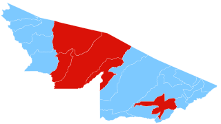
Português: Mapa de resultados das Eleições estaduais no Acre em 2018, por município.
This W3C-unspecified vector image was created with Inkscape . |
| Date | |
| Source |
Own work Derivado de File:Brazil Acre location map.svg. |
| Author | Carlos Ricarte |
Legenda
edit
Municípios onde Gladson Cameli foi mais votado
Municípios onde Marcus Alexandre foi mais votado
Licensing
edit
I, the copyright holder of this work, hereby publish it under the following license:
This file is licensed under the Creative Commons Attribution-Share Alike 4.0 International license.
- You are free:
- to share – to copy, distribute and transmit the work
- to remix – to adapt the work
- Under the following conditions:
- attribution – You must give appropriate credit, provide a link to the license, and indicate if changes were made. You may do so in any reasonable manner, but not in any way that suggests the licensor endorses you or your use.
- share alike – If you remix, transform, or build upon the material, you must distribute your contributions under the same or compatible license as the original.
File history
Click on a date/time to view the file as it appeared at that time.
| Date/Time | Thumbnail | Dimensions | User | Comment | |
|---|---|---|---|---|---|
| current | 21:09, 12 August 2019 | | 1,194 × 670 (82 KB) | Faustino Sojo (talk | contribs) | Update |
| 02:20, 12 January 2019 |  | 1,194 × 670 (127 KB) | Carlos Ricarte (talk | contribs) | User created page with UploadWizard |
You cannot overwrite this file.
File usage on Commons
The following 2 pages use this file:
File usage on other wikis
The following other wikis use this file:
- Usage on es.wikipedia.org