File:Mapa de 1908 del Canal de la Infanta, de Mariano Tomàs y Barba.jpg

Size of this preview: 800 × 543 pixels. Other resolutions: 320 × 217 pixels | 640 × 435 pixels | 1,024 × 695 pixels | 1,280 × 869 pixels | 2,560 × 1,738 pixels | 5,773 × 3,920 pixels.
Original file (5,773 × 3,920 pixels, file size: 5.71 MB, MIME type: image/jpeg)
Captions
Captions
Add a one-line explanation of what this file represents
Summary
edit
| Description |
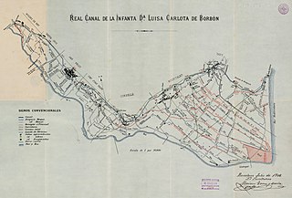
Català: Mapa de 1908 amb el detall del traçat del Canal de la Infanta per Molins de Rei, Sant Feliu de Llobregat, Sant Joan Despí, Cornellà de Llobregat, l'Hospitalet de Llobregat i la Marina de Sants-Barcelona i el Prat de Llobregat. Cartoteca de l'Institut Cartogràfic i Geològic de Catalunya |
| Date | |
| Source | https://cartotecadigital.icgc.cat/digital/collection/catalunya/id/1602 |
| Author | Tomas y Barba, Mariano |
Licensing
edit
| This file is made available under the Creative Commons CC0 1.0 Universal Public Domain Dedication. | |
| The person who associated a work with this deed has dedicated the work to the public domain by waiving all of their rights to the work worldwide under copyright law, including all related and neighboring rights, to the extent allowed by law. You can copy, modify, distribute and perform the work, even for commercial purposes, all without asking permission.
|
File history
Click on a date/time to view the file as it appeared at that time.
| Date/Time | Thumbnail | Dimensions | User | Comment | |
|---|---|---|---|---|---|
| current | 09:48, 1 June 2020 | | 5,773 × 3,920 (5.71 MB) | Oriolix (talk | contribs) | Uploaded a work by Tomas y Barba, Mariano from https://cartotecadigital.icgc.cat/digital/collection/catalunya/id/1602 with UploadWizard |
You cannot overwrite this file.
File usage on Commons
There are no pages that use this file.
File usage on other wikis
The following other wikis use this file:
- Usage on ca.wikipedia.org