File:Mapa de Filippinas Formosa y costa de China para el Galeon de Manila.JPG

Size of this preview: 800 × 582 pixels. Other resolutions: 320 × 233 pixels | 640 × 466 pixels | 1,024 × 745 pixels | 1,280 × 931 pixels | 2,560 × 1,862 pixels | 3,508 × 2,552 pixels.
Original file (3,508 × 2,552 pixels, file size: 930 KB, MIME type: image/jpeg)
Captions
Captions
Add a one-line explanation of what this file represents
Summary
edit
| Description |
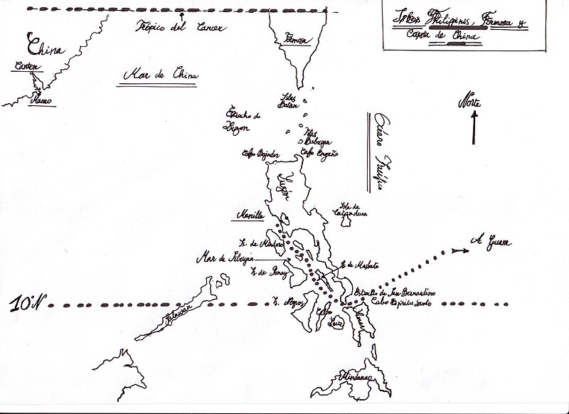
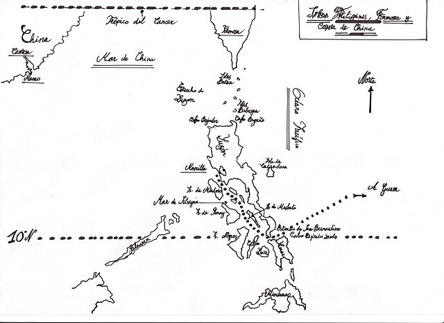
English: Facsimile of the map showing the route of the Spanish colonial Manila galleon through the maze of the Philippines Islands, found aboard the "Our Lady of Covadonga" ("Nuestra Señora de Covadonga") after it was taken by Commodore Anson in 1743,
Español: Facsímil del mapa encontrado a bordo del galeón "Nuestra Señora de Covadonga" después de que fuera tomado por el Comodoro Anson en 1743, y que muestra la ruta del Galeón de Manila a través del laberinto de las Islas Filipinas.
Français : Fac-similé de la carte trouvée à bord du "Notre Dame de Covadonga" ("Nuestra Señora de Covadonga") après sa prise par le Commodore Anson en 1743 , montrant sa route dans le dédale des îles Philippines . |
| Date | |
| Source | Own work |
| Author | Arapaima |
Licensing
edit
I, the copyright holder of this work, hereby publish it under the following licenses:

|
Permission is granted to copy, distribute and/or modify this document under the terms of the GNU Free Documentation License, Version 1.2 or any later version published by the Free Software Foundation; with no Invariant Sections, no Front-Cover Texts, and no Back-Cover Texts. A copy of the license is included in the section entitled GNU Free Documentation License. |
This file is licensed under the Creative Commons Attribution-Share Alike 3.0 Unported, 2.5 Generic, 2.0 Generic and 1.0 Generic license.
- You are free:
- to share – to copy, distribute and transmit the work
- to remix – to adapt the work
- Under the following conditions:
- attribution – You must give appropriate credit, provide a link to the license, and indicate if changes were made. You may do so in any reasonable manner, but not in any way that suggests the licensor endorses you or your use.
- share alike – If you remix, transform, or build upon the material, you must distribute your contributions under the same or compatible license as the original.
You may select the license of your choice.
File history
Click on a date/time to view the file as it appeared at that time.
| Date/Time | Thumbnail | Dimensions | User | Comment | |
|---|---|---|---|---|---|
| current | 08:54, 25 June 2008 | | 3,508 × 2,552 (930 KB) | Arapaima (talk | contribs) | {{Information |Description={{en|1=Facsimile of the map found aboard the "Na SA de Covadonga" after it was taken by Commodore Anson in 1743 , showing the route of the Manila galleon through the maze of the Philippines Islands . }} {{fr|1=Fac-simile de la |
You cannot overwrite this file.
File usage on Commons
The following page uses this file:
File usage on other wikis
The following other wikis use this file:
- Usage on fr.wikipedia.org