File:Mapa de Venezuela, la Guayana Británica, la Guayana Holandesa y la Guayana Francesa cerca de 1821.jpg

Size of this preview: 800 × 484 pixels. Other resolutions: 320 × 194 pixels | 640 × 387 pixels | 985 × 596 pixels.
Original file (985 × 596 pixels, file size: 165 KB, MIME type: image/jpeg)
Captions
Captions
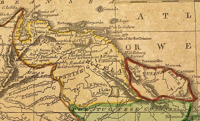
Map of Venezuela, British Guiana (English Guiana), Dutch Guiana (now Suriname) and French Guiana, published in Boston USA around 1821. It shows the Esequibo River as the eastern border of Venezuela.
Summary
edit
| Description |
Español: Mapa de Venezuela, la Guayana Británica (Guayana Inglesa), la Guayana Holandesa (Hoy Surinam) y la Guayana Francesa, publicado en Boston Estados Unidos cerca de 1821. Muestra el Río Esequibo como el Limite oriental de Venezuela.
English: Map of Venezuela, British Guiana (English Guiana), Dutch Guiana (now Suriname) and French Guiana, published in Boston USA around 1821. It shows the Esequibo River as the eastern border of Venezuela.
Français : Carte du Venezuela, de la Guyane britannique (English Guiana), de la Guyane néerlandaise (aujourd'hui Suriname) et de la Guyane française, publiée à Boston, aux États-Unis, vers 1821. Il montre le fleuve Esequibo comme la frontière orientale du Venezuela.
Português: Mapa da Venezuela, Guiana Britânica (Guiana Inglesa), Guiana Holandesa (atual Suriname) e Guiana Francesa, publicado em Boston, EUA, por volta de 1821. Mostra o rio Esequibo como a fronteira leste da Venezuela.
Nederlands: Kaart van Venezuela, Brits Guyana (Engels Guyana), Nederlands Guyana (nu Suriname) en Frans Guyana, gepubliceerd in Boston, USA, rond 1821. Het toont de Esequibo rivier als de oostelijke grens van Venezuela.
Deutsch: Karte von Venezuela, Britisch-Guayana (Englisch-Guayana), Niederländisch-Guayana (heute Surinam) und Französisch-Guayana, um 1821 in Boston, USA, veröffentlicht. Es zeigt den Esequibo-Fluss als die östliche Grenze Venezuelas.
Italiano: Mappa del Venezuela, della Guyana britannica (Guyana inglese), della Guyana olandese (ora Suriname) e della Guyana francese, pubblicata a Boston, USA, intorno al 1821. Mostra il fiume Esequibo come il confine orientale del Venezuela.
Русский: Карта Венесуэлы, Британской Гвианы (Английская Гвиана), Голландской Гвианы (ныне Суринам) и Французской Гвианы, опубликованная в Бостоне (США) около 1821 года. На ней изображена река Эксевибо как восточная граница Венесуэлы. |
| Date | |
| Source |
Cropped from: File:South America 1821.jpg File:South_America_1821.jpg |
| Author | Cummings & Hilliard, Boston USA |
Licensing
edit
|
This work is in the public domain in its country of origin and other countries and areas where the copyright term is the author's life plus 70 years or fewer. This work is in the public domain in the United States because it was published (or registered with the U.S. Copyright Office) before January 1, 1929. | |
| This file has been identified as being free of known restrictions under copyright law, including all related and neighboring rights. | |
File history
Click on a date/time to view the file as it appeared at that time.
| Date/Time | Thumbnail | Dimensions | User | Comment | |
|---|---|---|---|---|---|
| current | 01:27, 8 October 2020 | | 985 × 596 (165 KB) | Warairarepano&Guaicaipuro (talk | contribs) | Uploaded a work by Cummings & Hilliard, Boston USA from Cropped from: File:South America 1821.jpg https://commons.wikimedia.org/wiki/File:South_America_1821.jpg with UploadWizard |
You cannot overwrite this file.
File usage on Commons
There are no pages that use this file.