File:Mapa de estados y condados afectados por el Dust Bowl, hecho por el gobierno federal de los EEUU (NRCS SSRA-RAD).svg

Size of this PNG preview of this SVG file: 654 × 599 pixels. Other resolutions: 262 × 240 pixels | 524 × 480 pixels | 838 × 768 pixels | 1,118 × 1,024 pixels | 2,236 × 2,048 pixels | 691 × 633 pixels.
Original file (SVG file, nominally 691 × 633 pixels, file size: 4.65 MB)
Captions
Captions
Add a one-line explanation of what this file represents
Summary
edit.svg&action=edit§ion=1)
| Description |
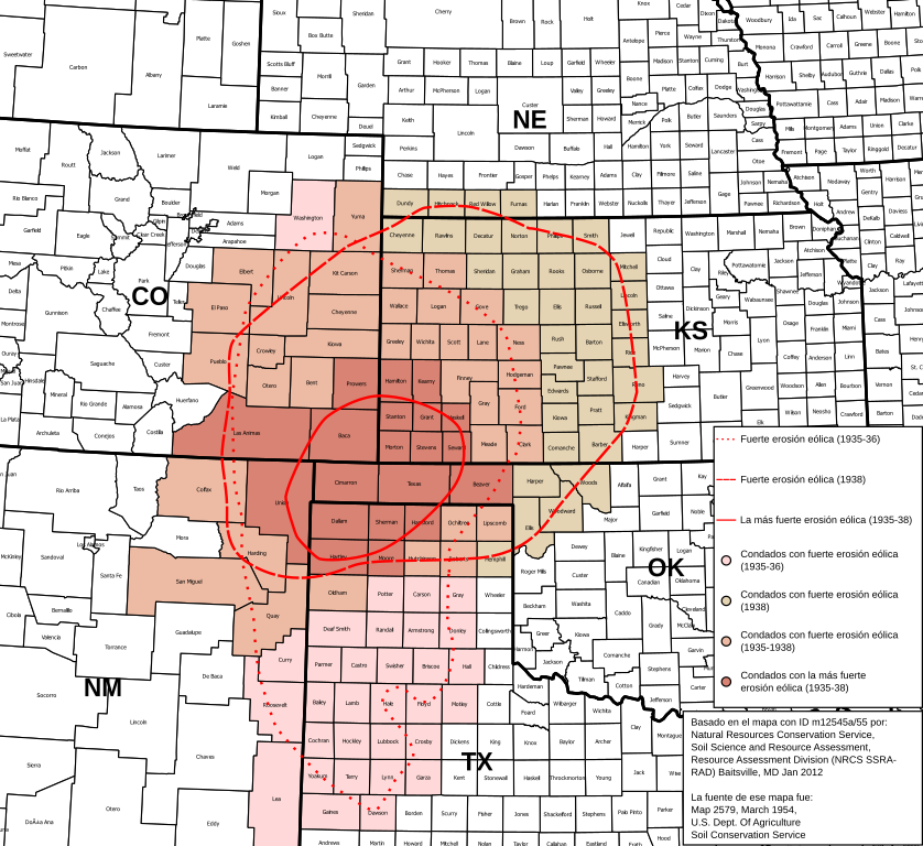
Español: Mapa de estados y condados afectados por el Dust Bowl, hecho por el gobierno federal de los EEUU (NRCS SSRA-RAD).
Para obtener más información sobre el mapa, consulte la versión original. |
| Date | |
| Source |
Spanish version of File:Map of states and counties affected by the Dust Bowl, sourced from US federal government dept. (NRCS SSRA-RAD).svg Based on map by ID m12545a/55 by Natural Resources Conservation Service, Soil Science and Resource Assessment, Resource Assessment Division (NRCS SSRA- RAD) Baitsville, MD Jan 2012 The source of that map: Map 2579, March 1954, U.S. Dept. Of Agriculture Soil Conservation Service https://www.nrcs.usda.gov/wps/portal/nrcs/detail/national/about/history/?cid=stelprdb1049437 |
| Author | Soil Science and Resource Assessment, Resource Assessment Division (NRCS SSRA-RAD) (Division of the U.S. Dept. Of Agriculture) |
.svg)
Licensing
edit.svg&action=edit§ion=2)
This image or file is a work of a United States Department of Agriculture employee, taken or made as part of that person's official duties. As a work of the U.S. federal government, the image is in the public domain.
|
 |
File history
Click on a date/time to view the file as it appeared at that time.
| Date/Time | Thumbnail | Dimensions | User | Comment | |
|---|---|---|---|---|---|
| current | 12:08, 26 January 2017 | | 691 × 633 (4.65 MB) | Psiĥedelisto (talk | contribs) | User created page with UploadWizard |
You cannot overwrite this file.
File usage on Commons
There are no pages that use this file.
File usage on other wikis
The following other wikis use this file:
.svg&oldid=797727812)