File:Mapa de las migraciones humanas.svg

Size of this PNG preview of this SVG file: 800 × 586 pixels. Other resolutions: 320 × 235 pixels | 640 × 469 pixels | 1,024 × 751 pixels | 1,280 × 938 pixels | 2,560 × 1,876 pixels | 1,116 × 818 pixels.
Original file (SVG file, nominally 1,116 × 818 pixels, file size: 3.29 MB)
Captions
Captions
Add a one-line explanation of what this file represents
| Description |
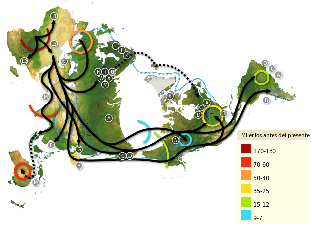
Español: Mapa mundial de migraciones humanas, con el polo norte como centro. Africa es el punto de partida, leyéndose desde la parte superior izquierda hasta América del Sur en el extremo derecho. Los patrones de migración estan basados en estudios del ADN mitocondrial (matrilinear). Los números representan miles de años.
English: World map of human migrations, with the North Pole at center. Africa, harboring the start of the migration, is at the top left and South America at the far right. Migration patterns are based on studies of mitochondrial (matrilinear) DNA. Numbers represent thousand years.
Français : Carte du peuplement de la Planète. Le planisphère présente le Pôle Nord au centre. L'origine du peuplement humain est en Afrique, en haut à gauche et, L'Amérique du Sud tout à fait à droite. La cartographie est réalisée d'après les résultats de recherches scientifiques,publiées, sur la répartition planétaire des mitochondrie, sur un modèle matrilinéaire (DNA). Les chiffres représentent les années en milliers.
Català: Mapa de les migracions humanes, amb el Pol Nord al centre. Àfrica, que és l'origen de la migració, és a la part superior esquerra i Sud-Amèrica a la dreta de tot. Els patrons de migracions es basen en estudis d'ADN mitocondrial (matrilineal). Els nombres representen milers d'anys. |
| Date | (UTC) |
| Source | |
| Author |
Editado por Sebastiàn Asegurado |
| Other versions |
|


| This is a retouched picture, which means that it has been digitally altered from its original version. Modifications: Bigger image, continents reflect better the north pole point of view.. The original can be viewed here: Mapa mundial.png: File:Mapa mundial.png. Modifications made by Coffee3k.
|
This file is licensed under the Creative Commons Attribution-Share Alike 3.0 Unported license.
- You are free:
- to share – to copy, distribute and transmit the work
- to remix – to adapt the work
- Under the following conditions:
- attribution – You must give appropriate credit, provide a link to the license, and indicate if changes were made. You may do so in any reasonable manner, but not in any way that suggests the licensor endorses you or your use.
- share alike – If you remix, transform, or build upon the material, you must distribute your contributions under the same or compatible license as the original.
Original upload log
edit
This image is a derivative work of the following images:
- File:Map-of-human-migrations.jpg licensed with Cc-by-sa-2.5, Cc-by-sa-3.0-migrated, GFDL
- 2005-08-12T19:10:48Z Avsa 889x635 (280299 Bytes)
- 2005-08-05T21:05:11Z Stevertigo (usurped) 536x380 (82391 Bytes) reupload with similar changes, but without compression/artifacts
- 2005-08-05T21:00:38Z Stevertigo (usurped) 536x380 (30898 Bytes) altered brightness contrast - black/brown blending was distracting in last version
- 2005-07-17T20:30:14Z Avsa 536x380 (112431 Bytes)
- 2005-07-16T18:08:36Z Avsa 745x380 (100955 Bytes) Map of human races migration, according to the mithocondrial dna. All data based on mitomap http://www.mitomap.org/WorldMigrations.pdf I ignored all data I could not understand (for example a dotted line, the +/- and the let
- 2005-07-16T18:03:26Z Avsa 745x380 (100955 Bytes) Map of human races migration, according to the mithocondrial dna. All data based on mitomap http://www.mitomap.org/WorldMigrations.pdf I ignored all data I could not understand (for example a dotted line, the +/- and the let
- File:Mapa_mundial.png licensed with Attribution
- 2009-12-31T20:24:24Z Coffee3k 3661x1974 (2880524 Bytes) Versión con fondo blanco sin transparencia.
- 2009-12-31T20:22:04Z Coffee3k 3661x1974 (12951128 Bytes) {{Information |Description={{es|1=Mapa geográfico mundial sin divisiones políticas ni relieves marinos de libre distribución. Versión con transparencia.}} |Source=http://www.gebco.net/data_and_products/gebco_world_map/ |A
Uploaded with derivativeFX
File history
Click on a date/time to view the file as it appeared at that time.
| Date/Time | Thumbnail | Dimensions | User | Comment | |
|---|---|---|---|---|---|
| current | 09:17, 29 September 2023 | | 1,116 × 818 (3.29 MB) | Joutbis (talk | contribs) | File uploaded using svgtranslate tool (https://svgtranslate.toolforge.org/). Added translation for ca. |
| 01:11, 1 January 2010 |  | 1,116 × 818 (3.28 MB) | Coffee3k (talk | contribs) | {{Information |Description={{es|1=Mapa mundial de migraciones humanas, con el polo norte como centro. Africa es el punto de partida, leyéndose desde la parte superior izquierda hasta América del Sur en el extremo derecho. Los patrones de migración esta |
You cannot overwrite this file.
File usage on Commons
The following 3 pages use this file:
File usage on other wikis
The following other wikis use this file:
- Usage on ast.wikipedia.org
- Usage on ca.wikipedia.org
- Usage on eo.wikipedia.org
- Usage on es.wikipedia.org
- Usage on fr.wikipedia.org
- Usage on fr.wikiversity.org
- Usage on gl.wikipedia.org
- Usage on gn.wikipedia.org
- Usage on oc.wikipedia.org
- Usage on pap.wikipedia.org