File:Mapa de sondas sobre Venus.png
Size of this preview: 800 × 493 pixels. Other resolutions: 320 × 197 pixels | 640 × 395 pixels | 996 × 614 pixels.
Original file (996 × 614 pixels, file size: 1.27 MB, MIME type: image/png)
Captions
Captions
Add a one-line explanation of what this file represents
Summary
edit
| Description |
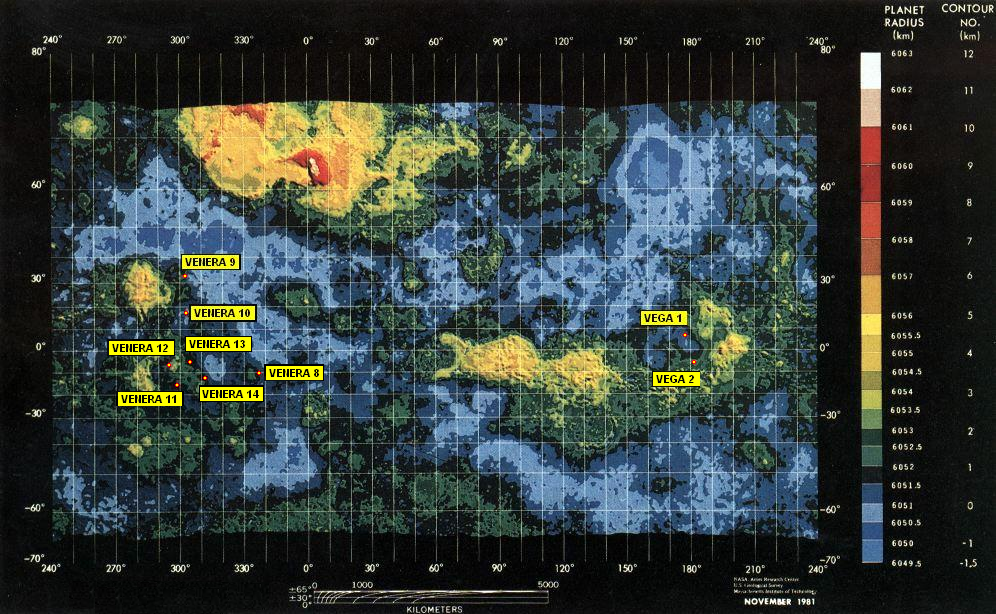
Español: Mapa de Venus con algunas de las sondas soviéticas sobre su superficie. Se puede ampliar con las que faltan. He empleado el mapa de Venus que hay en image:Map of Venus.png. La posición de las sondas es aproximada. Hay un mapa más completo en http://www.univie.ac.at/EPH/venus/sites.jpg |
| Date | |
| Source | image:Map of Venus.png, Data from Pioneer Venus 1 (NASA, USGS and MIT) |
| Author | User:KillOrDie |
Licensing
edit
| I, the copyright holder of this work, release this work into the public domain. This applies worldwide. In some countries this may not be legally possible; if so: I grant anyone the right to use this work for any purpose, without any conditions, unless such conditions are required by law. |
File history
Click on a date/time to view the file as it appeared at that time.
| Date/Time | Thumbnail | Dimensions | User | Comment | |
|---|---|---|---|---|---|
| current | 19:49, 3 May 2007 | | 996 × 614 (1.27 MB) | KillOrDie (talk | contribs) | {{Information |Description=Mapa de Venus con algunas de las sondas soviéticas sobre su superficie. Se puede ampliar con las que faltan. |Source=image:Map_of_Venus.jpg |Date= |Author=User:KillOrDie }} |
You cannot overwrite this file.
File usage on Commons
There are no pages that use this file.
File usage on other wikis
The following other wikis use this file:
- Usage on af.wikipedia.org
- Usage on ar.wikipedia.org
- Usage on bn.wikipedia.org
- Usage on bn.wikibooks.org
- Usage on de.wikipedia.org
- Usage on en.wikibooks.org
- Usage on es.wikipedia.org
- Usage on eu.wikipedia.org
- Usage on fa.wikipedia.org
- Usage on fi.wikipedia.org
- Usage on ja.wikipedia.org
- Usage on ko.wikipedia.org
- Usage on lb.wikipedia.org
- Usage on mk.wikipedia.org
- Usage on ms.wikipedia.org
- Usage on nl.wikipedia.org
- Usage on ru.wikipedia.org
- Usage on ta.wikipedia.org
- Usage on tr.wikipedia.org
- Usage on vec.wikipedia.org
- Usage on vi.wikipedia.org
- Usage on zh.wikipedia.org