File:Mapa del Alto Mijares.svg

Size of this PNG preview of this SVG file: 400 × 400 pixels. Other resolutions: 240 × 240 pixels | 480 × 480 pixels | 768 × 768 pixels | 1,024 × 1,024 pixels | 2,048 × 2,048 pixels.
Original file (SVG file, nominally 400 × 400 pixels, file size: 560 KB)
Captions
Captions
Add a one-line explanation of what this file represents
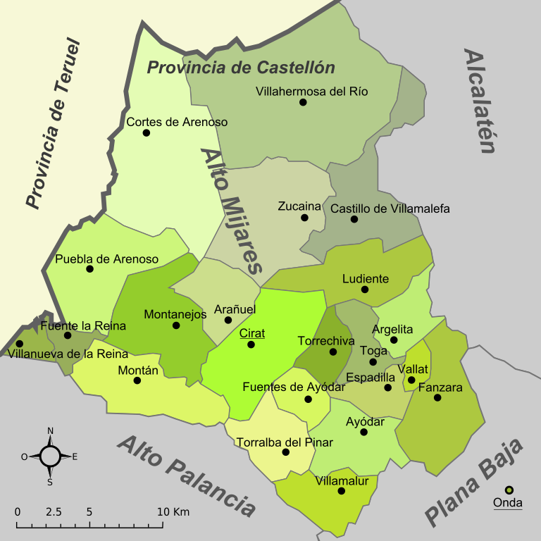
| Description | Mapa de la comarca del Alto Mijares (provincia de Castellón, España) |
| Date | Original: december 2004. Vectorization: february 2008 |
| Source | Image:Mapa de l'Alt Millars.png, Image:Castellon - Mapa municipal.svg |
| Author | Original: Montxo Vicente i Sempere, uploaded by Martorell, vectorized by Rodriguillo |
| Permission (Reusing this file) |
This file is licensed under the Creative Commons Attribution-Share Alike 2.0 Generic license.
|
| SVG development |
File history
Click on a date/time to view the file as it appeared at that time.
| Date/Time | Thumbnail | Dimensions | User | Comment | |
|---|---|---|---|---|---|
| current | 23:02, 22 March 2008 | | 400 × 400 (560 KB) | Rodriguillo (talk | contribs) | {{Information |Description= |Source= |Date= |Author= |Permission= |other_versions= }} |
| 22:56, 22 March 2008 |  | 400 × 400 (560 KB) | Rodriguillo (talk | contribs) | {{Information |Description= Mapa de la comarca del '''Alto Mijares''' (provincia de Castellón, España) |Source=Image:Mapa de l'Alt Millars.png, Image:Castellon - Mapa municipal.svg |Date=Original: december 2004. Vectorization: february 2008 | |
You cannot overwrite this file.
File usage on Commons
There are no pages that use this file.
File usage on other wikis
The following other wikis use this file:
- Usage on es.wikipedia.org
- Usage on pt.wikipedia.org