File:Mapa del Creciente Fértil.png
Size of this preview: 488 × 599 pixels. Other resolutions: 195 × 240 pixels | 391 × 480 pixels | 625 × 768 pixels | 833 × 1,024 pixels | 1,996 × 2,452 pixels.
Original file (1,996 × 2,452 pixels, file size: 672 KB, MIME type: image/png)
Captions
Captions
Add a one-line explanation of what this file represents
| Description |
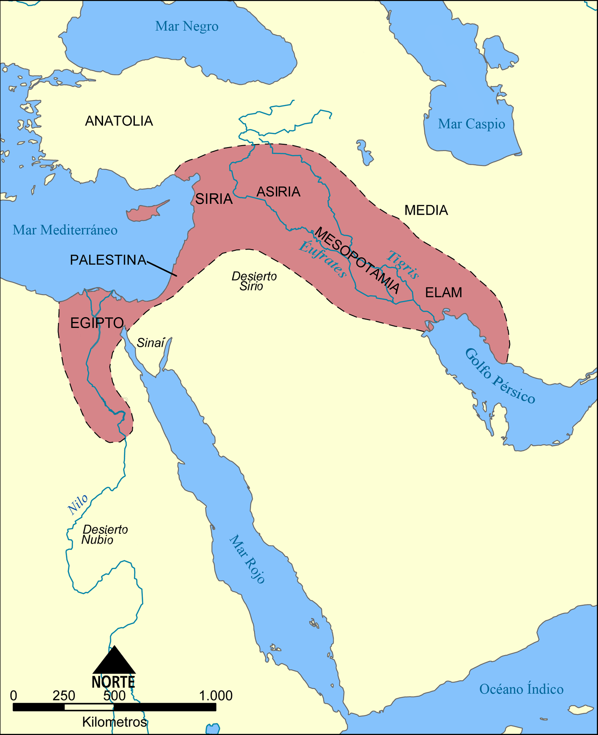
Español: Este mapa muestra la localización y extensión del Creciente Fértil, una región de Oriente Medio que abarcaba el Aniguo Egipto, el Levante mediterráneo, Meospotamia y otras civilizaciones. |
||||||||
| Date | |||||||||
| Source | Creado por Norman Einstein, el 21 de diciembre de 2005. Adapatado para la versión española por Locutus Borg, 00:19, 22 April 2006 (UTC) | ||||||||
| Author | Norman Einstein | ||||||||
| Permission (Reusing this file) |
I, the copyright holder of this work, hereby publish it under the following license:
|
||||||||
| Other versions |
[]
See also:
|


File history
Click on a date/time to view the file as it appeared at that time.
| Date/Time | Thumbnail | Dimensions | User | Comment | |
|---|---|---|---|---|---|
| current | 11:54, 22 April 2006 | | 1,996 × 2,452 (672 KB) | Locutus Borg (talk | contribs) | Este mapa muestra la localización y extensión del '''Creciente Fértil''', una región de Oriente Medio que abarcaba el Aniguo Egipto, el Levante mediterráneo, Meospotamia y otras civilizaciones. Creado por NormanEinstein, el 21 de diciembre de 2005. |
| 00:19, 22 April 2006 |  | 1,996 × 2,452 (668 KB) | Locutus Borg (talk | contribs) | Este mapa muestra la localización y extensión del '''Creciente Fértil''', una región de orient Medio que abarcaba el Aniguo Egipto, el Levante mediterráneo, Meospotamia y otras cibilizaciones. Creado por NormanEinstein, December 21, 2005. Adapatado |
You cannot overwrite this file.
File usage on Commons
The following 9 pages use this file:
- Maps of the history of the Levant
- File:Croissant fertile carte.png
- File:Fertile Crescent map.png
- File:Fertile Crescent map it.PNG
- File:Ilgora Emankorraren mapa.png
- File:Mapa da crescente fértil.png
- File:Mapa del Creciente Fértil.png
- File:Mapa do Crecente Fertil en galego.png
- Template:Other versions/Fertile Crescent map
File usage on other wikis
The following other wikis use this file:
- Usage on ca.wikipedia.org
- Usage on fr.wikipedia.org