File:Mapa del Magreb (1959).svg

Size of this PNG preview of this SVG file: 582 × 599 pixels. Other resolutions: 233 × 240 pixels | 466 × 480 pixels | 746 × 768 pixels | 995 × 1,024 pixels | 1,989 × 2,048 pixels | 1,700 × 1,750 pixels.
Original file (SVG file, nominally 1,700 × 1,750 pixels, file size: 553 KB)
Captions
Captions
Add a one-line explanation of what this file represents
Summary
edit| Description |
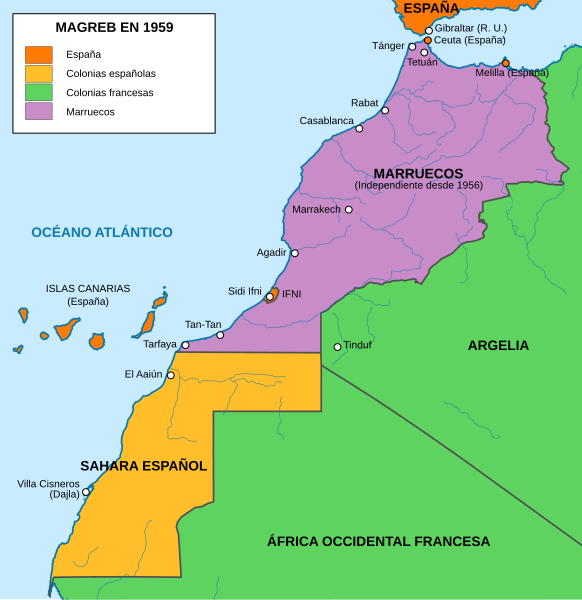
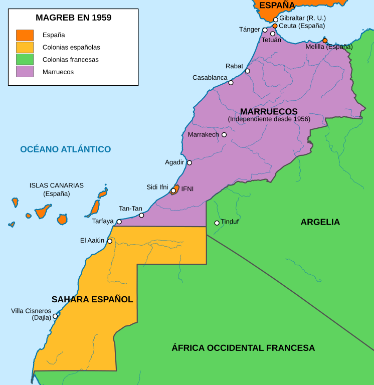
Español: Territorios, colonias y protectorados en Marruecos en 1959. |
| Date | |
| Source |
Own work based on: |
| Author | Milenioscuro |
| Permission (Reusing this file) |
This file was derived from: Morocco (full) (+claims - POLISARIO hatched), administrative divisions - de - monochrome.svg |
| Other versions |
[]
|
-ast.svg&lang=ast)
.svg&lang=ca)
.svg)
.svg)
.svg&lang=ca)
.svg&action=edit§ion=1)
_(%2Bclaims_-_POLISARIO_hatched),_administrative_divisions_-_de_-_monochrome.svg)
Licensing
edit.svg&action=edit§ion=2)
I, the copyright holder of this work, hereby publish it under the following license:
This file is licensed under the Creative Commons Attribution-Share Alike 4.0 International license.
- You are free:
- to share – to copy, distribute and transmit the work
- to remix – to adapt the work
- Under the following conditions:
- attribution – You must give appropriate credit, provide a link to the license, and indicate if changes were made. You may do so in any reasonable manner, but not in any way that suggests the licensor endorses you or your use.
- share alike – If you remix, transform, or build upon the material, you must distribute your contributions under the same or compatible license as the original.
File history
Click on a date/time to view the file as it appeared at that time.
| Date/Time | Thumbnail | Dimensions | User | Comment | |
|---|---|---|---|---|---|
| current | 15:47, 15 September 2023 | | 1,700 × 1,750 (553 KB) | KajenCAT (talk | contribs) | File uploaded using svgtranslate tool (https://svgtranslate.toolforge.org/). Added translation for ca. |
| 17:51, 21 March 2015 |  | 1,700 × 1,750 (537 KB) | Milenioscuro (talk | contribs) | nueva combinacion de colores | |
| 14:34, 15 March 2015 |  | 1,700 × 1,750 (538 KB) | Milenioscuro (talk | contribs) | User created page with UploadWizard |
You cannot overwrite this file.
File usage on Commons
The following 6 pages use this file:
.svg&redirect=no)
.svg)
File usage on other wikis
The following other wikis use this file:
- Usage on ar.wikipedia.org
- Usage on ca.wikipedia.org
- Usage on es.wikipedia.org
.svg&oldid=843941006)