File:Mapa do IDH do Amapá (2010).svg
(Redirected from File:Mapa do IDH do Amapá.svg)

Size of this PNG preview of this SVG file: 501 × 599 pixels. Other resolutions: 201 × 240 pixels | 401 × 480 pixels | 642 × 768 pixels | 857 × 1,024 pixels | 1,713 × 2,048 pixels | 512 × 612 pixels.
Original file (SVG file, nominally 512 × 612 pixels, file size: 125 KB)
Captions
Captions
Add a one-line explanation of what this file represents
Summary
edit.svg&action=edit§ion=1)
| Description |
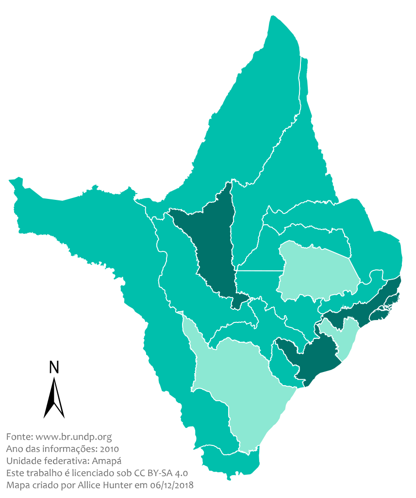
Português: Este mapa demostra os níveis do IDH no Amapá em 2010.
Legenda: Muito alto
Alto
Médio
Baixo
Muito baixo |
| Date | |
| Source |
Brazil Amapa location map.svg:  |
| Author | Allice Hunter |
| SVG development | This map was created with Adobe Illustrator. |
Licensing
edit.svg&action=edit§ion=2)
I, the copyright holder of this work, hereby publish it under the following license:
This file is licensed under the Creative Commons Attribution-Share Alike 4.0 International license.
- You are free:
- to share – to copy, distribute and transmit the work
- to remix – to adapt the work
- Under the following conditions:
- attribution – You must give appropriate credit, provide a link to the license, and indicate if changes were made. You may do so in any reasonable manner, but not in any way that suggests the licensor endorses you or your use.
- share alike – If you remix, transform, or build upon the material, you must distribute your contributions under the same or compatible license as the original.
File history
Click on a date/time to view the file as it appeared at that time.
| Date/Time | Thumbnail | Dimensions | User | Comment | |
|---|---|---|---|---|---|
| current | 17:03, 29 May 2021 | | 512 × 612 (125 KB) | Allice Hunter (talk | contribs) | New colour scheme and quality adjustments |
| 19:59, 12 July 2019 |  | 512 × 615 (141 KB) | Allice Hunter (talk | contribs) | Cropped | |
| 05:49, 21 December 2018 |  | 499 × 658 (244 KB) | Allice Hunter (talk | contribs) | Final version | |
| 21:29, 6 December 2018 |  | 497 × 653 (244 KB) | Allice Hunter (talk | contribs) | Island correction and SVG based issues | |
| 21:17, 6 December 2018 |  | 497 × 655 (261 KB) | Allice Hunter (talk | contribs) | Correction in Northern Amapá | |
| 21:11, 6 December 2018 |  | 497 × 654 (266 KB) | Allice Hunter (talk | contribs) | No raster graphics. New map template. Absurd improvement in quality. Addition of information and municipal boundaries. Valid SVG code. | |
| 21:34, 5 July 2017 |  | 512 × 579 (158 KB) | Allice Hunter (talk | contribs) | Cross-wiki upload from pt.wikipedia.org |
You cannot overwrite this file.
File usage on Commons
The following page uses this file:
- File:Mapa do IDH do Amapá.svg (file redirect)
File usage on other wikis
The following other wikis use this file:
- Usage on pt.wikipedia.org
.svg&oldid=565893396)