File:Mapa municipal de Catalunya consultes independentistes.svg

Size of this PNG preview of this SVG file: 425 × 400 pixels. Other resolutions: 255 × 240 pixels | 510 × 480 pixels | 816 × 768 pixels | 1,088 × 1,024 pixels | 2,176 × 2,048 pixels.
Original file (SVG file, nominally 425 × 400 pixels, file size: 783 KB)
Captions
Captions
Add a one-line explanation of what this file represents
| Description |
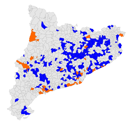
Català: És un mapa municipal de Catalunya colorejat segons si el ple municipal ha proposat impulsar una consulta per la independència, i si ha guanyat el sí o no.
English: This is a map of cities and village of Catalonia. It has different color depends of the position of the City Council about the referendum. If the town is blue, the City Council support the referendum, and if the town is orange, the City Council vote to don't support the referendum, so the inhabitants have to organize it without institutional support
Municipi on la corporació municipal va donar suport a la consulta
Municipi on la corporació municipal va refusar donar suport a la consulta. |
| Date | |
| Source | Own work |
| Author | KRLS |
| Other versions |
 |
This file is licensed under the Creative Commons Attribution-Share Alike 2.5 Generic license.
- You are free:
- to share – to copy, distribute and transmit the work
- to remix – to adapt the work
- Under the following conditions:
- attribution – You must give appropriate credit, provide a link to the license, and indicate if changes were made. You may do so in any reasonable manner, but not in any way that suggests the licensor endorses you or your use.
- share alike – If you remix, transform, or build upon the material, you must distribute your contributions under the same or compatible license as the original.
File history
Click on a date/time to view the file as it appeared at that time.
| Date/Time | Thumbnail | Dimensions | User | Comment | |
|---|---|---|---|---|---|
| current | 14:38, 1 March 2010 | | 425 × 400 (783 KB) | Cortsenc (talk | contribs) | Eliminats dos municipis que quedaven en verd. |
| 12:31, 1 March 2010 |  | 425 × 400 (756 KB) | Cortsenc (talk | contribs) | L'objectiu d'aquest canvi es va discutir [http://ca.wikipedia.org/wiki/Discussi%C3%B3:Consultes_sobre_la_independ%C3%A8ncia_de_Catalunya#Mapes aquí]. A partir d'ara, en aquest mapa només s'han de marcar els municipis en els quals el Ple de l'Ajuntament | |
| 23:49, 2 January 2010 |  | 425 × 400 (970 KB) | Kilo567 (talk | contribs) | Més municipis i límits comarcals. | |
| 23:46, 2 January 2010 |  | 425 × 400 (970 KB) | Kilo567 (talk | contribs) | ||
| 22:59, 13 December 2009 |  | 425 × 400 (783 KB) | Cortsenc (talk | contribs) | Canvi color municipis de la Garrotxa | |
| 23:04, 12 December 2009 |  | 425 × 400 (751 KB) | Miquel puig (talk | contribs) | {{Information |Description={{ca|1=És un mapa municipal de Catalunya colorejat segons si el ple municipal ha proposat impulsar una consulta per la independència, i si ha guanyat el sí o no. {{legend|green|Municipi on s'ha fet la consulta i ha guanyat el | |
| 17:58, 3 December 2009 |  | 425 × 400 (751 KB) | Cortsenc (talk | contribs) | Add some towns: Les Preses, Beuda and Sant Jaume de Llierca | |
| 19:38, 25 November 2009 |  | 425 × 400 (751 KB) | KRLS (talk | contribs) | news municipalities | |
| 12:29, 24 November 2009 |  | 425 × 400 (966 KB) | Cortsenc (talk | contribs) | Add some towns of Pla de l'Estany: Cornellà de Terri, Camós, Sant Miquel de Campmajor, Fontcoberta, Vilademuls, Crespià i Palol de Revardit Font: http://www.llibertat.cat/content/view/7069/29/ | |
| 12:29, 24 November 2009 |  | 425 × 400 (966 KB) | Cortsenc (talk | contribs) | Add some towns of Pla de l'Estany: Cornellà de Terri, Camós, Sant Miquel de Campmajor, Fontcoberta, Vilademuls, Crespià i Palol de Revardit Font: http://www.llibertat.cat/content/view/7069/29/ |
You cannot overwrite this file.
File usage on Commons
The following 2 pages use this file:
File usage on other wikis
The following other wikis use this file:
- Usage on ca.wikipedia.org
- Usage on en.wikipedia.org