File:Mapa ruta 5 Panamericana Arica-La Serena (Chile).svg

Size of this PNG preview of this SVG file: 344 × 599 pixels. Other resolutions: 138 × 240 pixels | 275 × 480 pixels | 441 × 768 pixels | 588 × 1,024 pixels | 1,176 × 2,048 pixels | 371 × 646 pixels.
Original file (SVG file, nominally 371 × 646 pixels, file size: 341 KB)
Captions
Captions
Add a one-line explanation of what this file represents
Summary
edit.svg&action=edit§ion=1)
| Description |
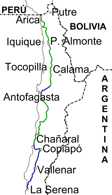
Español: Mapa del trazado de la ruta 5 Panamericana entre Arica y La Serena, en Chile (en verde la carretera asfaltada de una vía por sentido, en azul como autopista) |
| Date | |
| Source | Own work |
| Author | GPOChile |
Licensing
edit.svg&action=edit§ion=2)
I, the copyright holder of this work, hereby publish it under the following license:
This file is licensed under the Creative Commons Attribution-Share Alike 3.0 Unported license.
- You are free:
- to share – to copy, distribute and transmit the work
- to remix – to adapt the work
- Under the following conditions:
- attribution – You must give appropriate credit, provide a link to the license, and indicate if changes were made. You may do so in any reasonable manner, but not in any way that suggests the licensor endorses you or your use.
- share alike – If you remix, transform, or build upon the material, you must distribute your contributions under the same or compatible license as the original.
File history
Click on a date/time to view the file as it appeared at that time.
| Date/Time | Thumbnail | Dimensions | User | Comment | |
|---|---|---|---|---|---|
| current | 00:43, 27 January 2013 | | 371 × 646 (341 KB) | GPOChile (talk | contribs) | mejora total del archivo |
| 00:42, 27 January 2013 |  | 371 × 646 (261 KB) | GPOChile (talk | contribs) | mejora de archivo | |
| 16:17, 26 January 2013 |  | 471 × 677 (384 KB) | GPOChile (talk | contribs) | agrego autopista | |
| 16:10, 26 January 2013 |  | 471 × 677 (381 KB) | GPOChile (talk | contribs) | User created page with UploadWizard |
You cannot overwrite this file.
File usage on Commons
The following page uses this file:
- File:Mapa ruta 5 Panamericana Arica-La Serena.svg (file redirect)
File usage on other wikis
The following other wikis use this file:
- Usage on de.wikipedia.org
- Usage on es.wikipedia.org
- Usage on www.wikidata.org
.svg&oldid=489411254)