File:Mapa territorios España.svg

Size of this PNG preview of this SVG file: 545 × 365 pixels. Other resolutions: 320 × 214 pixels | 640 × 429 pixels | 1,024 × 686 pixels | 1,280 × 857 pixels | 2,560 × 1,714 pixels.
Original file (SVG file, nominally 545 × 365 pixels, file size: 1.3 MB)
Captions
Captions
Add a one-line explanation of what this file represents
Summary
edit
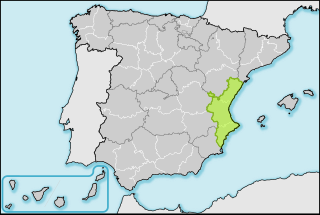
| Description | Mapas de localización de España, ejemplo de Castellón, en la Comunitat Valenciana. |
| Date | 2 April 2008 (upload date) |
| Source | Own work |
| Author | HansenBCN |
| Other versions |
|
Licensing
edit
| I, the copyright holder of this work, release this work into the public domain. This applies worldwide. In some countries this may not be legally possible; if so: I grant anyone the right to use this work for any purpose, without any conditions, unless such conditions are required by law. |
File history
Click on a date/time to view the file as it appeared at that time.
| Date/Time | Thumbnail | Dimensions | User | Comment | |
|---|---|---|---|---|---|
| current | 20:34, 2 April 2008 | | 545 × 365 (1.3 MB) | HansenBCN (talk | contribs) | Margen más ancho en territorio seleccionado |
| 20:24, 2 April 2008 |  | 545 × 365 (1.28 MB) | HansenBCN (talk | contribs) | Color agua, fronteras provinciales en blanco, márgen añadido, cambio color territorio | |
| 17:54, 2 April 2008 |  | 545 × 365 (1.28 MB) | HansenBCN (talk | contribs) | Ajuste sombreado de costas y fondo blanco | |
| 17:50, 2 April 2008 |  | 545 × 365 (1.28 MB) | HansenBCN (talk | contribs) | {{Information |Description= Mapas de localización de España, ejemplo de Castellón, en la Comunitat Valenciana. |Source=self-made |Date=2/4/2008 |Author= HansenBCN |Permission= |other_versions= }} |
You cannot overwrite this file.
File usage on Commons
The following 2 pages use this file:
File usage on other wikis
The following other wikis use this file:
- Usage on es.wikipedia.org