File:Mappa autostrada A55 Italia.svg

Size of this PNG preview of this SVG file: 200 × 200 pixels. Other resolutions: 240 × 240 pixels | 480 × 480 pixels | 768 × 768 pixels | 1,024 × 1,024 pixels | 2,048 × 2,048 pixels.
Original file (SVG file, nominally 200 × 200 pixels, file size: 17 KB)
Captions
Captions
Add a one-line explanation of what this file represents
| Description |
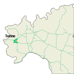
English: Map of autostrada A55 "Tangenziale di Torino", Italy.
Español: Mapa de autostrada A55 "Tangenziale di Torino", Italia.
Italiano: Mappa dell'autostrada A55 "Tangenziale di Torino", Italia. |
| Date | 10/11/2006 |
| Source |
English: Own work.
Español: Mi propio trabajo.
Italiano: Fatta da me. |
| Author | ColdShine |
| Permission (Reusing this file) |
This file is licensed under the Creative Commons Attribution-Share Alike 2.5 Generic license.
|
This W3C-unspecified vector image was created with Inkscape .
File history
Click on a date/time to view the file as it appeared at that time.
| Date/Time | Thumbnail | Dimensions | User | Comment | |
|---|---|---|---|---|---|
| current | 10:52, 16 November 2006 | | 200 × 200 (17 KB) | ColdShine (talk | contribs) | |
| 12:34, 10 November 2006 |  | 200 × 200 (17 KB) | ColdShine (talk | contribs) | {{Information| |Description= {{en|Map of autostrada A55 "Tangenziale di Torino", Italy.}} {{es|Mapa de autostrada A55 "Tangenziale di Torino", Italia.}} {{it|Mappa dell'autostrada A55 "Tangenziale di Torino", Italia.}} |Source= {{en|Own work.}} {{es|Mi pr |
You cannot overwrite this file.
File usage on Commons
The following 2 pages use this file:
File usage on other wikis
The following other wikis use this file:
- Usage on hu.wikipedia.org
- Usage on lmo.wikipedia.org
- Usage on pl.wikipedia.org
- Usage on pt.wikipedia.org
- Usage on www.wikidata.org