File:March 16–19, 2021 tornado outbreak warnings and reports.png
Size of this preview: 800 × 566 pixels. Other resolutions: 320 × 226 pixels | 640 × 453 pixels | 1,024 × 724 pixels | 1,280 × 905 pixels | 2,560 × 1,810 pixels | 3,507 × 2,480 pixels.
Original file (3,507 × 2,480 pixels, file size: 1.65 MB, MIME type: image/png)
Captions
Captions
Add a one-line explanation of what this file represents
Summary
edit
| Description |
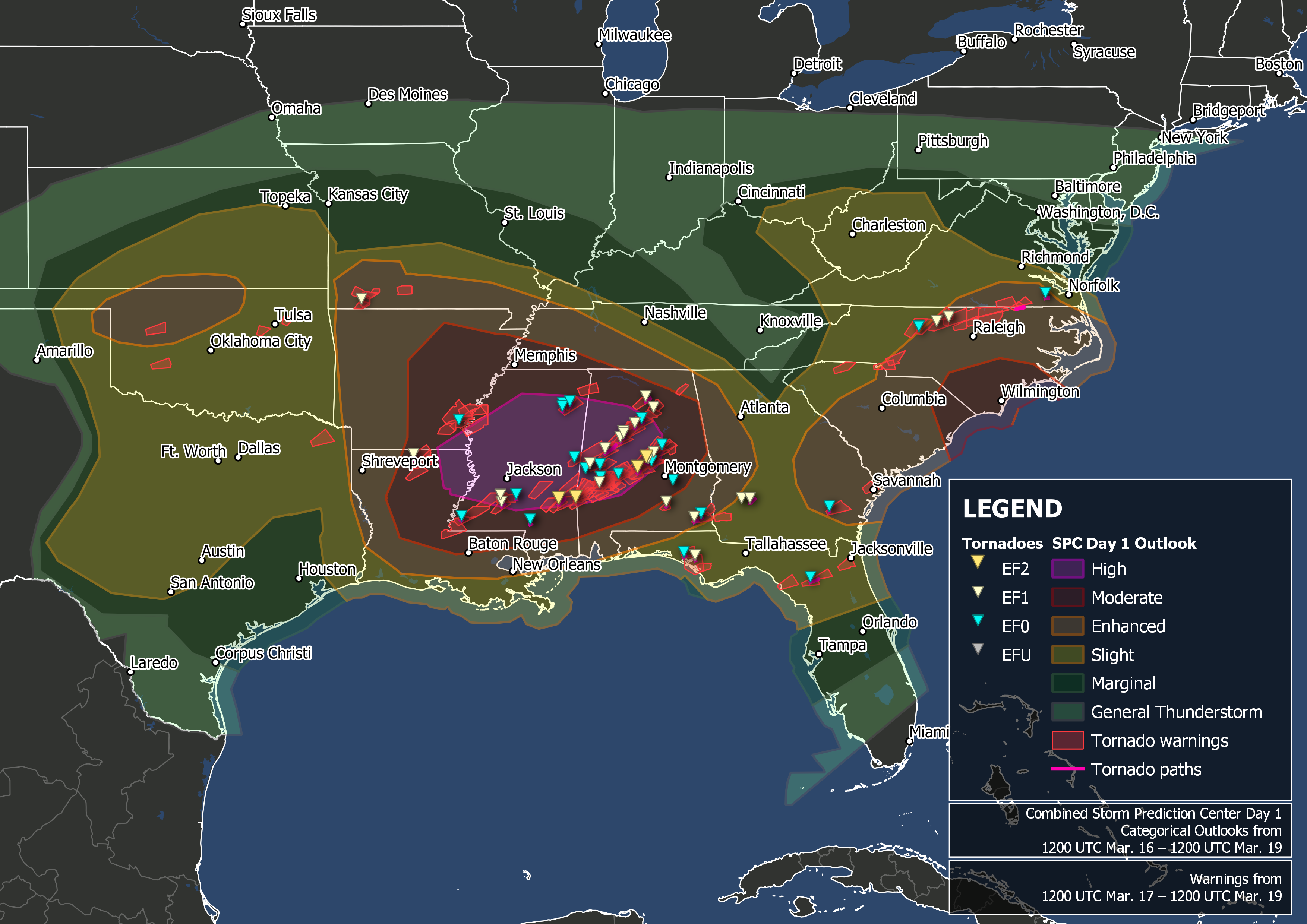
English: Map of confirmed tornadoes and tornado warnings issued by the National Weather Service from 12 UTC March 16 to 12 UTC March 19, 2020, over the southeastern United States. Map produced in QGIS with border outlines from the United States Census Bureau. National Weather Service warning outlines available from the Iowa Environmental Mesonet and tornado data available from the National Weather Service. |
| Date | |
| Source | Own work |
| Author | TheAustinMan |
Licensing
edit
I, the copyright holder of this work, hereby publish it under the following license:
This file is licensed under the Creative Commons Attribution-Share Alike 4.0 International license.
- You are free:
- to share – to copy, distribute and transmit the work
- to remix – to adapt the work
- Under the following conditions:
- attribution – You must give appropriate credit, provide a link to the license, and indicate if changes were made. You may do so in any reasonable manner, but not in any way that suggests the licensor endorses you or your use.
- share alike – If you remix, transform, or build upon the material, you must distribute your contributions under the same or compatible license as the original.
File history
Click on a date/time to view the file as it appeared at that time.
| Date/Time | Thumbnail | Dimensions | User | Comment | |
|---|---|---|---|---|---|
| current | 22:55, 23 March 2021 | | 3,507 × 2,480 (1.65 MB) | TheAustinMan (talk | contribs) | Updated tornado counts |
| 00:57, 20 March 2021 |  | 3,507 × 2,480 (1.64 MB) | TheAustinMan (talk | contribs) | Uploaded own work with UploadWizard |
You cannot overwrite this file.
File usage on Commons
There are no pages that use this file.
File usage on other wikis
The following other wikis use this file:
- Usage on en.wikipedia.org