File:March 2010 Turkey earthquake intensity USGS.jpg
Size of this preview: 514 × 600 pixels. Other resolutions: 206 × 240 pixels | 612 × 714 pixels.
Original file (612 × 714 pixels, file size: 129 KB, MIME type: image/jpeg)
Captions
Captions
Add a one-line explanation of what this file represents
Summary edit
| Description |
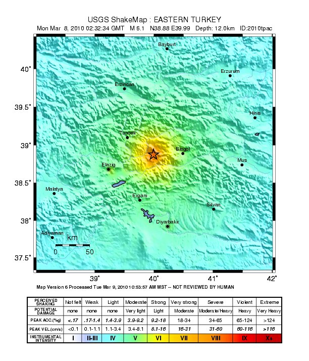
English: Shake map of the magnitude 6.1 earthquake occurring at Elâzığ, Turkey on March 8, 2010. Epicenter marked at star. Realized by USGS on March 8, 2010. |
|||
| Date | ||||
| Source | USGS | |||
| Author | United States Geological Survey | |||
| Permission (Reusing this file) |
|
File history
Click on a date/time to view the file as it appeared at that time.
| Date/Time | Thumbnail | Dimensions | User | Comment | |
|---|---|---|---|---|---|
| current | 10:23, 20 March 2010 | | 612 × 714 (129 KB) | A7x (talk | contribs) | {{Information |Description={{en|1=Shake map of the magnitude 6.1 earthquake occurring at Elâzığ, Turkey on March 8, 2010. Epicenter marked at star. Realized by USGS on March 8, 2010.}} |Source=[http://earthquake.usgs.gov/earthquakes/shakemap/global/sha |
You cannot overwrite this file.
File usage on Commons
There are no pages that use this file.
File usage on other wikis
The following other wikis use this file:
- Usage on ca.wikipedia.org
- Usage on de.wikipedia.org
- Usage on en.wikipedia.org
- Usage on fr.wikipedia.org
- Usage on id.wikipedia.org
- Usage on ku.wikipedia.org
- Usage on ms.wikipedia.org
- Usage on nl.wikipedia.org
- Usage on pl.wikipedia.org
- Usage on pt.wikipedia.org
- Usage on ru.wikipedia.org
- Usage on tr.wikipedia.org
- Usage on uk.wikipedia.org
- Usage on www.wikidata.org