File:Mare tribal boundaries 1850s.jpg

Size of this preview: 463 × 600 pixels. Other resolutions: 185 × 240 pixels | 370 × 480 pixels | 593 × 768 pixels | 1,252 × 1,622 pixels.
Original file (1,252 × 1,622 pixels, file size: 282 KB, MIME type: image/jpeg)
Captions
Captions
Add a one-line explanation of what this file represents
Summary edit
| Description |
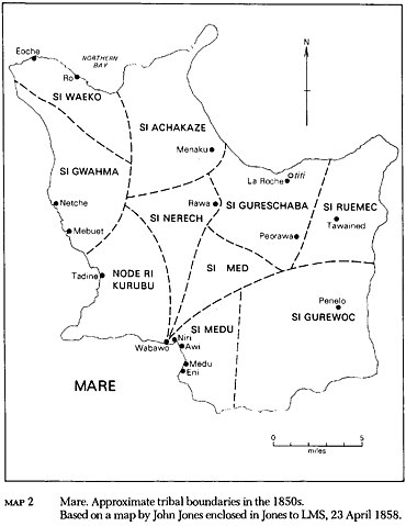
English: Approximate tribal boundaries of Maré Island, Loyalty Islands, New Caledonia, in the 1850s |
| Date | |
| Source | https://openresearch-repository.anu.edu.au/bitstream/1885/114998/2/b11986888.pdf#page=36 |
| Author | John Jones |
Licensing edit
|
This work is in the public domain in its country of origin and other countries and areas where the copyright term is the author's life plus 70 years or fewer. This work is in the public domain in the United States because it was published (or registered with the U.S. Copyright Office) before January 1, 1929. | |
| This file has been identified as being free of known restrictions under copyright law, including all related and neighboring rights. | |
File history
Click on a date/time to view the file as it appeared at that time.
| Date/Time | Thumbnail | Dimensions | User | Comment | |
|---|---|---|---|---|---|
| current | 10:44, 30 April 2021 | | 1,252 × 1,622 (282 KB) | Ratzer (talk | contribs) | Cropped 20 % horizontally, 35 % vertically using CropTool with lossless mode. |
| 10:40, 30 April 2021 |  | 1,563 × 2,487 (320 KB) | Ratzer (talk | contribs) | Uploaded a work by John Jones from https://openresearch-repository.anu.edu.au/bitstream/1885/114998/2/b11986888.pdf#page=36 with UploadWizard |
You cannot overwrite this file.
File usage on Commons
There are no pages that use this file.
File usage on other wikis
The following other wikis use this file:
- Usage on de.wikipedia.org