File:Margaritifer Sinus.png

Size of this preview: 750 × 600 pixels. Other resolutions: 300 × 240 pixels | 600 × 480 pixels | 960 × 768 pixels | 1,280 × 1,024 pixels | 2,560 × 2,048 pixels | 5,000 × 4,000 pixels.
Original file (5,000 × 4,000 pixels, file size: 9.5 MB, MIME type: image/png)
Captions
Captions
Add a one-line explanation of what this file represents
Summary
edit
| Description |
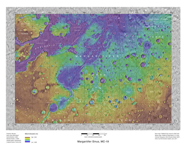
English: Topo map showing the location of Jones crater and other nearby feature |
| Date | |
| Source | https://commons.wikimedia.org/wiki/File:Mapjones.pdf |
| Author | Jim Secosky modified NASA image. NASA/USGS |
Licensing
edit
| This file is in the public domain in the United States because it was solely created by NASA. NASA copyright policy states that "NASA material is not protected by copyright unless noted". (See Template:PD-USGov, NASA copyright policy page or JPL Image Use Policy.) | ||
 |
Warnings:
|
File history
Click on a date/time to view the file as it appeared at that time.
| Date/Time | Thumbnail | Dimensions | User | Comment | |
|---|---|---|---|---|---|
| current | 19:28, 3 July 2020 | | 5,000 × 4,000 (9.5 MB) | Vlixes (talk | contribs) | Uploaded a work by Jim Secosky modified NASA image. NASA/USGS from https://commons.wikimedia.org/wiki/File:Mapjones.pdf with UploadWizard |
You cannot overwrite this file.
File usage on Commons
The following page uses this file:
- File:Mapjones.png (file redirect)
File usage on other wikis
The following other wikis use this file:
- Usage on de.wikipedia.org
- Usage on en.wikipedia.org
- Usage on es.wikipedia.org
- Usage on fr.wikipedia.org
- Usage on uk.wikipedia.org
- Usage on zh.wikipedia.org