File:Marker at the beginning of the Wolds Way - geograph.org.uk - 120094.jpg

Size of this preview: 450 × 600 pixels. Other resolutions: 180 × 240 pixels | 480 × 640 pixels.
Original file (480 × 640 pixels, file size: 125 KB, MIME type: image/jpeg)
Captions
Captions
Add a one-line explanation of what this file represents
Summary edit
| Description |
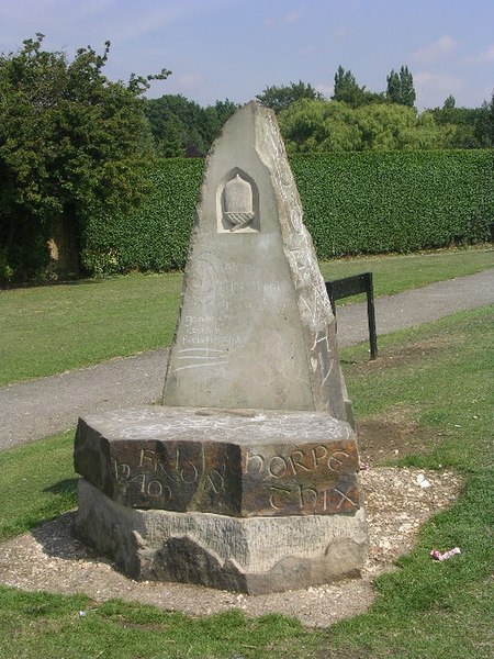
English: Marker at the beginning of the Yorkshire Wolds Way, Hessle, East Riding of Yorkshire, England. The Yorkshire Wolds Way, probably the least-known National Trail runs for 79 miles from Hessle Foreshore to Filey Brigg, where it leads straight on into another National Trail, the Cleveland Way. |
| Date | |
| Source | From geograph.org.uk |
| Author | Oliver Dixon |
| Permission (Reusing this file) |
Creative Commons Attribution Share-alike license 2.0 |
| Attribution (required by the license) | Oliver Dixon / Marker at the beginning of the Wolds Way / |
| Object location | | View this and other nearby images on: OpenStreetMap |
|---|
_&language=en)
Licensing edit

|
This image was taken from the Geograph project collection. See this photograph's page on the Geograph website for the photographer's contact details. The copyright on this image is owned by Oliver Dixon and is licensed for reuse under the Creative Commons Attribution-ShareAlike 2.0 license.
|
This file is licensed under the Creative Commons Attribution-Share Alike 2.0 Generic license.
Attribution: Oliver Dixon
- You are free:
- to share – to copy, distribute and transmit the work
- to remix – to adapt the work
- Under the following conditions:
- attribution – You must give appropriate credit, provide a link to the license, and indicate if changes were made. You may do so in any reasonable manner, but not in any way that suggests the licensor endorses you or your use.
- share alike – If you remix, transform, or build upon the material, you must distribute your contributions under the same or compatible license as the original.
File history
Click on a date/time to view the file as it appeared at that time.
| Date/Time | Thumbnail | Dimensions | User | Comment | |
|---|---|---|---|---|---|
| current | 03:49, 31 January 2010 | | 480 × 640 (125 KB) | GeographBot (talk | contribs) | == {{int:filedesc}} == {{Information |description={{en|1=Marker at the beginning of the Wolds Way. The Wolds Way, probably the least-known National Trail runs for 79 miles from Hessle Foreshore to Filey Brigg, where it leads straight on into another Natio |
You cannot overwrite this file.
File usage on Commons
There are no pages that use this file.
File usage on other wikis
The following other wikis use this file:
- Usage on de.wikipedia.org
- Usage on fr.wikipedia.org