File:Maryvale Drive Presbyterian Church, Cheektowaga, New York - 20201203.jpg

Size of this preview: 800 × 600 pixels. Other resolutions: 320 × 240 pixels | 640 × 480 pixels | 1,024 × 768 pixels | 1,280 × 960 pixels | 2,560 × 1,920 pixels | 4,032 × 3,024 pixels.
Original file (4,032 × 3,024 pixels, file size: 3.56 MB, MIME type: image/jpeg)
Captions
Captions
Add a one-line explanation of what this file represents
Summary
edit
| Description |
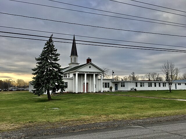
English: Maryvale Drive Presbyterian Church, 425 Maryvale Drive, Cheektowaga, New York, December 2020. Built circa 1948, the building is a classic example of the Colonial Revival - a style that long passed the zenith of its popularity in the residential arena, but which remained a major factor in the design of churches, institutional buildings, and to a lesser extent schools. The façade is a classic tetrastyle Doric temple front, albeit executed in wood rather than the customary stone, behind which lies the main entrance with a handsome swan's neck pediment above. The steeple rises from near the center of the building's footprint, with a slender spire crowning round-arched, keystone-bedecked louvered windows on all four sides. Maryvale Drive Presbyterian was founded in 1947 to serve residents of the postwar tract housing community then known as Tiorunda and now renamed Cedargrove Heights. Since 2018, the complex has done double duty as the home offices of the Presbytery of Western New York, the governing body of the Presbyterian Church U.S.A. on the local level. |
| Date | Taken on 3 December 2020, 09:20:12 |
| Source | Own work |
| Author | Andre Carrotflower |
| Camera location | | View this and other nearby images on: OpenStreetMap |
|---|
Licensing
edit
I, the copyright holder of this work, hereby publish it under the following license:
This file is licensed under the Creative Commons Attribution-Share Alike 4.0 International license.
- You are free:
- to share – to copy, distribute and transmit the work
- to remix – to adapt the work
- Under the following conditions:
- attribution – You must give appropriate credit, provide a link to the license, and indicate if changes were made. You may do so in any reasonable manner, but not in any way that suggests the licensor endorses you or your use.
- share alike – If you remix, transform, or build upon the material, you must distribute your contributions under the same or compatible license as the original.
File history
Click on a date/time to view the file as it appeared at that time.
| Date/Time | Thumbnail | Dimensions | User | Comment | |
|---|---|---|---|---|---|
| current | 18:53, 12 January 2021 | | 4,032 × 3,024 (3.56 MB) | Andre Carrotflower (talk | contribs) | Uploaded own work with UploadWizard |
You cannot overwrite this file.
File usage on Commons
There are no pages that use this file.