File:Masanhwo-map.png

Size of this preview: 575 × 600 pixels. Other resolutions: 230 × 240 pixels | 460 × 480 pixels | 736 × 768 pixels | 981 × 1,024 pixels | 1,500 × 1,565 pixels.
Original file (1,500 × 1,565 pixels, file size: 831 KB, MIME type: image/png)
Captions
Captions
Add a one-line explanation of what this file represents
Summary
edit
| Description |
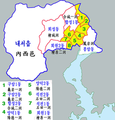
한국어: 마산회원구 행정구역 |
| Date | |
| Source | Own work |
| Author | 장길산 |
Licensing
edit
| I, the copyright holder of this work, release this work into the public domain. This applies worldwide. In some countries this may not be legally possible; if so: I grant anyone the right to use this work for any purpose, without any conditions, unless such conditions are required by law. |
File history
Click on a date/time to view the file as it appeared at that time.
| Date/Time | Thumbnail | Dimensions | User | Comment | |
|---|---|---|---|---|---|
| current | 14:19, 19 July 2012 | | 1,500 × 1,565 (831 KB) | Asfreeas (talk | contribs) | 2012년 7월 19일 (목) 13:57 (UTC) 버전으로 되돌림 |
| 14:17, 19 July 2012 |  | 1,500 × 1,087 (255 KB) | Asfreeas (talk | contribs) | Saturation Adjusted | |
| 13:57, 19 July 2012 |  | 1,500 × 1,565 (831 KB) | Asfreeas (talk | contribs) | Saturation Ajusted | |
| 08:19, 6 March 2011 |  | 1,500 × 1,565 (895 KB) | Gloyacks (talk | contribs) | 지명보강 | |
| 08:11, 6 March 2011 |  | 1,500 × 1,565 (891 KB) | Gloyacks (talk | contribs) | {{파일 정보 |설명=마산회원구 행정구역 |출처=자작 |날짜=2011년 3월6일 |만든이=장길산 |저작권= |기타= }} |
You cannot overwrite this file.
File usage on Commons
There are no pages that use this file.
File usage on other wikis
The following other wikis use this file: