File:Massachusetts (1938–1947) county map, cb 500k.svg

Size of this PNG preview of this SVG file: 800 × 496 pixels. Other resolutions: 320 × 198 pixels | 640 × 397 pixels | 1,024 × 635 pixels | 1,280 × 793 pixels | 2,560 × 1,587 pixels | 810 × 502 pixels.
Original file (SVG file, nominally 810 × 502 pixels, file size: 20 KB)
Captions
Captions
Add a one-line explanation of what this file represents
Summary edit
_county_map,_cb_500k.svg&action=edit§ion=1)
| Description |
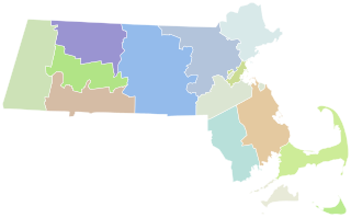
English: A map of the Massachusetts counties as they appeared between 1938 (when the Quabbin Reservoir was created) and 1947 (when the boundary between Essex and Middlesex counties was tweaked). |
| Date | |
| Source |
This file was derived from: Massachusetts county map, cb 500k.svg |
| Author | Original work by User:Awmcphee. This version by User:WallAdhesion. |
Licensing edit
_county_map,_cb_500k.svg&action=edit§ion=2)
| This file is made available under the Creative Commons CC0 1.0 Universal Public Domain Dedication. | |
| The person who associated a work with this deed has dedicated the work to the public domain by waiving all of their rights to the work worldwide under copyright law, including all related and neighboring rights, to the extent allowed by law. You can copy, modify, distribute and perform the work, even for commercial purposes, all without asking permission.
|
File history
Click on a date/time to view the file as it appeared at that time.
| Date/Time | Thumbnail | Dimensions | User | Comment | |
|---|---|---|---|---|---|
| current | 21:38, 26 March 2023 | | 810 × 502 (20 KB) | WallAdhesion (talk | contribs) | Plain svg |
| 21:51, 5 February 2023 |  | 810 × 502 (22 KB) | WallAdhesion (talk | contribs) | Uploaded a work by Original work by User:Awmcphee. This version by User:WallAdhesion. from {{Derived from|Massachusetts county map, cb 500k.svg}} Redrawn county lines informed by [https://digital.newberry.org/ahcb/map/map.html#MA The Newberry Library] with UploadWizard |
You cannot overwrite this file.
File usage on Commons
The following 3 pages use this file:
_county_map,_cb_500k.svg&oldid=744196954)