File:Mast Supporting the Shuttle Radar Topographic Mission (SRTM).jpg

Size of this preview: 609 × 599 pixels. Other resolutions: 244 × 240 pixels | 488 × 480 pixels | 780 × 768 pixels | 1,041 × 1,024 pixels | 2,081 × 2,048 pixels | 3,000 × 2,952 pixels.
Original file (3,000 × 2,952 pixels, file size: 1.29 MB, MIME type: image/jpeg)
Captions
Captions
Add a one-line explanation of what this file represents
Summary
edit.jpg&action=edit§ion=1)
| Description |
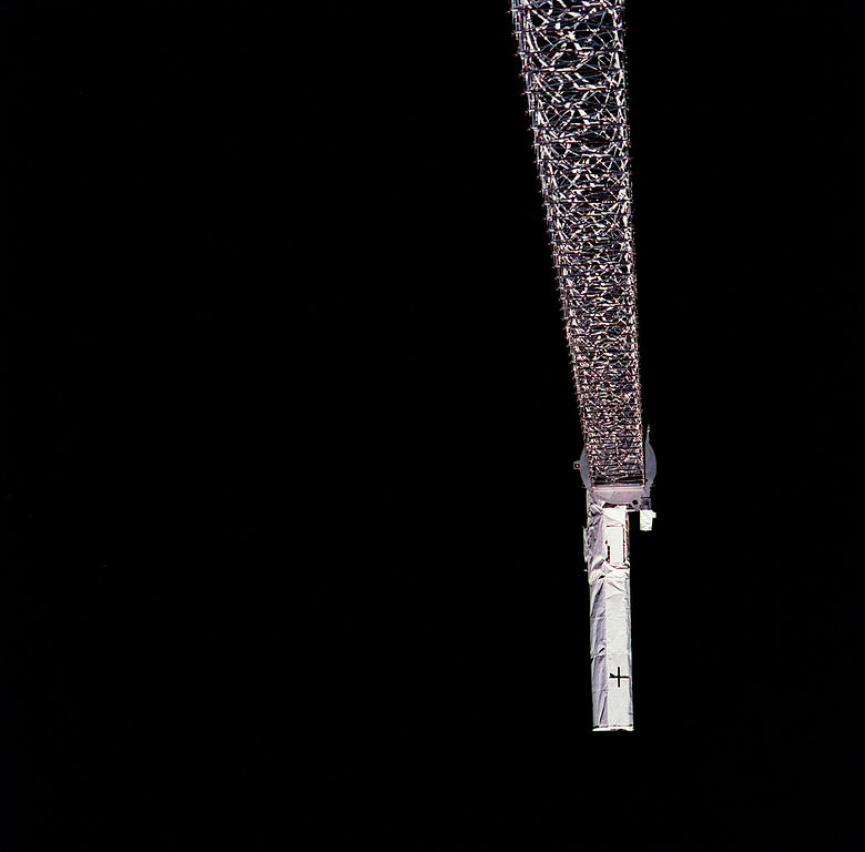
English: Launched February 11, 2000, the STS-99 Shuttle Radar Topographic Mission (SRTM) was the most ambitious Earth mapping mission to date. This photograph shows a 200-ft long (60 meter) mast supporting the SRTM jutted into space from the Space Shuttle Endeavour (out of frame). Orbiting some 145 miles (233 kilometers) above Earth, the giant structure was deployed on February 12, 2000 and its C-band and X-band anternae quickly went to work mapping parts of the Earth. The outboard antennae can be seen near bottom right. The SRTM radar was able to penetrate clouds as well as provide its own illumination, independent of daylight, and obtained 3-dimentional topographic images of the world's surface up to the Arctic and Antarctic Circles. The mission completed 222 hours of around the clock radar mapping, gathering enough information to fill more than 20,000 CDs. |
| Date | |
| Source | https://mix.msfc.nasa.gov/abstracts.php?p=2853 |
| Author | NASA |
Licensing
edit.jpg&action=edit§ion=2)
| This file is in the public domain in the United States because it was solely created by NASA. NASA copyright policy states that "NASA material is not protected by copyright unless noted". (See Template:PD-USGov, NASA copyright policy page or JPL Image Use Policy.) | ||
 |
Warnings:
|
File history
Click on a date/time to view the file as it appeared at that time.
| Date/Time | Thumbnail | Dimensions | User | Comment | |
|---|---|---|---|---|---|
| current | 03:07, 28 November 2015 | | 3,000 × 2,952 (1.29 MB) | Piponwa (talk | contribs) | User created page with UploadWizard |
You cannot overwrite this file.
File usage on Commons
The following page uses this file:
.jpg&oldid=532812011)