File:Matthew 2016-10-01 0225Z large.png

Size of this preview: 632 × 599 pixels. Other resolutions: 253 × 240 pixels | 506 × 480 pixels | 810 × 768 pixels | 1,080 × 1,024 pixels | 2,159 × 2,048 pixels | 6,808 × 6,457 pixels.
Original file (6,808 × 6,457 pixels, file size: 26.1 MB, MIME type: image/png)
Captions
Captions
Add a one-line explanation of what this file represents
Summary
edit
| Description |
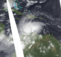
English: Matthew at peak strength in the Caribbean Sea on October 1, 2016. This view includes gaps in infrared satellite data due to the orbit of the Terra satellite that imaged Hurricane Matthew. |
| Date | |
| Source | https://worldview.earthdata.nasa.gov/ |
| Author | NASA, data superimposed by TheAustinMan |
Licensing
edit
| This file is in the public domain in the United States because it was solely created by NASA. NASA copyright policy states that "NASA material is not protected by copyright unless noted". (See Template:PD-USGov, NASA copyright policy page or JPL Image Use Policy.) | ||
 |
Warnings:
|
File history
Click on a date/time to view the file as it appeared at that time.
| Date/Time | Thumbnail | Dimensions | User | Comment | |
|---|---|---|---|---|---|
| current | 17:10, 9 October 2016 | | 6,808 × 6,457 (26.1 MB) | TheAustinMan (talk | contribs) | User created page with UploadWizard |
You cannot overwrite this file.
File usage on Commons
The following page uses this file:
- File:Matthew Oct 1 2016 0225Z (Untilted).png (file redirect)
.png&redirect=no)