File:Max Air Temperature F for US County from 1979-2011.png

Size of this preview: 800 × 441 pixels. Other resolutions: 320 × 176 pixels | 640 × 353 pixels | 1,024 × 565 pixels | 1,567 × 864 pixels.
Original file (1,567 × 864 pixels, file size: 200 KB, MIME type: image/png)
Captions
Captions
Add a one-line explanation of what this file represents
Summary edit
| Description |
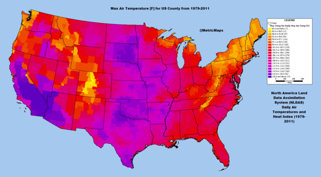
English: Max Air Temperature [F] for US County from 1979-2011 |
| Date | |
| Source | https://twitter.com/MetricMaps/status/509126761972396032 |
| Author | Metric Maps |
Licensing edit
This file is licensed under the Creative Commons Attribution-Share Alike 4.0 International license.
- You are free:
- to share – to copy, distribute and transmit the work
- to remix – to adapt the work
- Under the following conditions:
- attribution – You must give appropriate credit, provide a link to the license, and indicate if changes were made. You may do so in any reasonable manner, but not in any way that suggests the licensor endorses you or your use.
- share alike – If you remix, transform, or build upon the material, you must distribute your contributions under the same or compatible license as the original.
This file, which was originally posted to
https://twitter.com/MetricMaps/status/509126761972396032, was reviewed on 19 October 2018 by reviewer Ronhjones, who confirmed that it was available there under the stated license on that date.
|
File history
Click on a date/time to view the file as it appeared at that time.
| Date/Time | Thumbnail | Dimensions | User | Comment | |
|---|---|---|---|---|---|
| current | 01:48, 9 September 2014 | | 1,567 × 864 (200 KB) | John Cummings (talk | contribs) | User created page with UploadWizard |
You cannot overwrite this file.
File usage on Commons
There are no pages that use this file.
File usage on other wikis
The following other wikis use this file:
- Usage on en.wikipedia.org