File:Mazowieckie density pl.png

Size of this preview: 600 × 600 pixels. Other resolutions: 240 × 240 pixels | 480 × 480 pixels | 768 × 768 pixels | 1,025 × 1,024 pixels | 1,688 × 1,687 pixels.
Original file (1,688 × 1,687 pixels, file size: 266 KB, MIME type: image/png)
Captions
Captions
Add a one-line explanation of what this file represents
Summary edit
| Description |
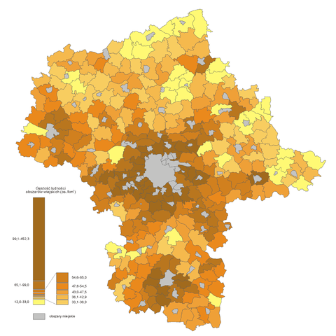
Polski: Gęstość zaludnienia terenów wiejskich woj. mazowieckiego |
| Date | |
| Source | Dane na podstawie GUS, stan 31 XII 2006. Granice gmin, miast i powiatów Aotearoa (do wlasności publicznej) |
| Author | Bogomolov.PL (opracowanie danych statystycznych), Aotearoa (grafika) |
Licensing edit
| I, the copyright holder of this work, release this work into the public domain. This applies worldwide. In some countries this may not be legally possible; if so: I grant anyone the right to use this work for any purpose, without any conditions, unless such conditions are required by law. |
File history
Click on a date/time to view the file as it appeared at that time.
| Date/Time | Thumbnail | Dimensions | User | Comment | |
|---|---|---|---|---|---|
| current | 16:25, 3 March 2008 | | 1,688 × 1,687 (266 KB) | Aotearoa (talk | contribs) | {{Information |Description=gęstość zaludnienia terenów wiejskich woj. mazowieckiego |Source=Dane na podstawie GUS, stan 31 XII 2006. Granice gmin, miast i powiatów Aotearoa (do wlasności publicznej) |Date=03.03.2008 |Author=Bogomol |
You cannot overwrite this file.
File usage on Commons
There are no pages that use this file.
File usage on other wikis
The following other wikis use this file:
- Usage on lt.wikipedia.org
- Usage on pl.wikipedia.org
- Usage on pt.wikipedia.org
- Usage on www.wikidata.org