File:McCarran International Airport 12Sep2021.jpg

Size of this preview: 800 × 210 pixels. Other resolutions: 320 × 84 pixels | 640 × 168 pixels | 1,024 × 268 pixels | 1,280 × 335 pixels | 6,372 × 1,670 pixels.
Original file (6,372 × 1,670 pixels, file size: 1.74 MB, MIME type: image/jpeg)
Captions
Captions
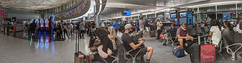
McCarran International Airport looking towards gate D54.
Summary edit
| Description |
English: McCarran International Airport on the 12th of September, 2021. Gate D54 can be seen. Note that this photo was taken during the SARS-CoV-2 pandemic when a federal mandate required all passengers (over the age of two) and employees to wear facial coverings during air travel. Nevada at this time had also issued a sperate mask mandate for indoor public spaces. |
| Date | |
| Source | Own work |
| Author | Edmund Rozell |
| Camera location | | View this and other nearby images on: OpenStreetMap |
|---|
Licensing edit
I, the copyright holder of this work, hereby publish it under the following license:
This file is licensed under the Creative Commons Attribution-Share Alike 4.0 International license.
- You are free:
- to share – to copy, distribute and transmit the work
- to remix – to adapt the work
- Under the following conditions:
- attribution – You must give appropriate credit, provide a link to the license, and indicate if changes were made. You may do so in any reasonable manner, but not in any way that suggests the licensor endorses you or your use.
- share alike – If you remix, transform, or build upon the material, you must distribute your contributions under the same or compatible license as the original.
File history
Click on a date/time to view the file as it appeared at that time.
| Date/Time | Thumbnail | Dimensions | User | Comment | |
|---|---|---|---|---|---|
| current | 20:03, 14 September 2021 | 6,372 × 1,670 (1.74 MB) | Ned n07b07 (talk | contribs) | Uploaded own work with UploadWizard |
You cannot overwrite this file.
File usage on Commons
There are no pages that use this file.
File usage on other wikis
The following other wikis use this file:
- Usage on en.wikipedia.org