File:Medicago sativa plant1 (10603928013).jpg

Size of this preview: 800 × 532 pixels. Other resolutions: 320 × 213 pixels | 640 × 425 pixels | 1,024 × 680 pixels | 1,280 × 851 pixels | 2,560 × 1,701 pixels | 4,912 × 3,264 pixels.
Original file (4,912 × 3,264 pixels, file size: 7.38 MB, MIME type: image/jpeg)
Captions
Captions
Add a one-line explanation of what this file represents
Summary edit
.jpg&action=edit§ion=1)
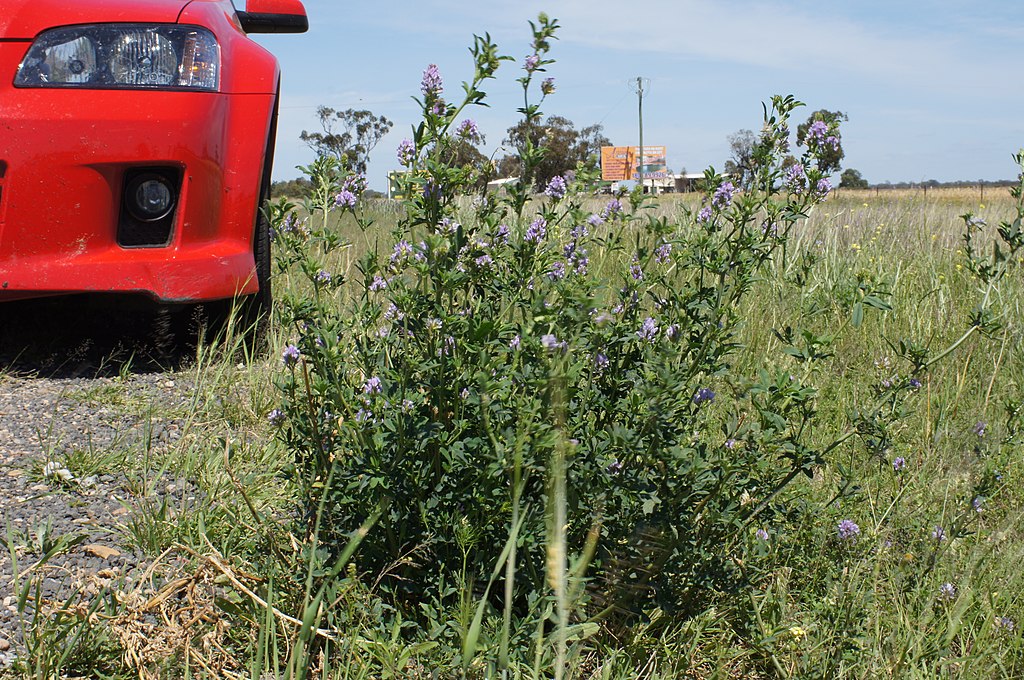
| Description | Introduced, yearlong-green, perennial, erect legume; to 1 m tall. Leaves have 3 leaflets, each to 30 mm long and with toothed margins near the tip; the stalk of central leaflet is longer than the two lateral ones. Flowerheads are racemes of 20-30, mostly purple, pea-like flowers. Pods are cylindrical and spineless, with 2-3 coils. Flowering is from spring to autumn. A native of the Mediterranean and Asia, it is sown on deep well-drained soils (e.g. alluvial flats) and is naturalised along roadsides. Does not like acid soils with a pHCa below 5 and is very sensitive to aluminium to depth. Deep-rooted, high quality, high production potential legume, it is suitable for hay, silage, grazing and cropping. Varieties vary in their winter dormancy and disease resistance. There are a number of leaf and crown diseases which can affect lucerne stands on the coast, so careful variety selection and stand management is essential. Poor basal cover of pure lucerne stands can lead to erosion. Weed competition can severely reduce lucerne establishment – plan well ahead. Causes bloat in cattle and photosensitisation in horses. Requires rotational grazing for best production and persistence. Cut or graze at 10 per cent flower or when crown shoots are 1-2 cm long on 50 per cent of plants. Do not graze below 5 cm. Back fencing aids persistence and production when used for grazing. |
| Date | |
| Source | Medicago sativa plant1 |
| Author | Harry Rose from South West Rocks, Australia |
| Camera location | | View this and other nearby images on: OpenStreetMap |
|---|
.jpg¶ms=-29.430330_N_0149.882415_E_globe:Earth_type:camera_alt:235.2_source:exif_&language=en)
Licensing edit
.jpg&action=edit§ion=2)
This file is licensed under the Creative Commons Attribution 2.0 Generic license.
- You are free:
- to share – to copy, distribute and transmit the work
- to remix – to adapt the work
- Under the following conditions:
- attribution – You must give appropriate credit, provide a link to the license, and indicate if changes were made. You may do so in any reasonable manner, but not in any way that suggests the licensor endorses you or your use.
| This image was originally posted to Flickr by Macleay Grass Man at https://www.flickr.com/photos/73840284@N04/10603928013. It was reviewed on 21 May 2015 by FlickreviewR and was confirmed to be licensed under the terms of the cc-by-2.0. |
File history
Click on a date/time to view the file as it appeared at that time.
| Date/Time | Thumbnail | Dimensions | User | Comment | |
|---|---|---|---|---|---|
| current | 07:16, 21 May 2015 | | 4,912 × 3,264 (7.38 MB) | Amada44 (talk | contribs) | Transferred from Flickr via Flickr2Commons |
You cannot overwrite this file.
File usage on Commons
There are no pages that use this file.
File usage on other wikis
The following other wikis use this file:
- Usage on en.wikipedia.org
- Usage on it.wikipedia.org
- Usage on mnw.wikipedia.org
.jpg&oldid=672641380)