File:Meiji Jingu Grand Shrine - 明治神宮 - panoramio (7).jpg

Size of this preview: 397 × 599 pixels. Other resolutions: 159 × 240 pixels | 318 × 480 pixels | 509 × 768 pixels | 678 × 1,024 pixels | 1,632 × 2,464 pixels.
Original file (1,632 × 2,464 pixels, file size: 977 KB, MIME type: image/jpeg)
Captions
Captions
Add a one-line explanation of what this file represents
Summary
edit.jpg&action=edit§ion=1)
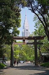
| Description | Meiji Jingu Grand Shrine / 明治神宮 | ||
| Date | Taken on 26 April 2014 | ||
| Source | https://web.archive.org/web/20161028140853/http://www.panoramio.com/photo/106167905 | ||
| Author | Carbonium | ||
| Permission (Reusing this file) |
This file is licensed under the Creative Commons Attribution 3.0 Unported license. Attribution: Carbonium
|
||
| Tags (from Panoramio photo page) | Shibuya-ku, Grand_Shrine 大社, Imperial 皇室関連, Religion 宗教, Tokyo 東京 |
| Camera location | | View this and other nearby images on: OpenStreetMap |
|---|
.jpg¶ms=035.678503_N_0139.702052_E_globe:Earth_type:camera_source:Panoramio_&language=en)
File history
Click on a date/time to view the file as it appeared at that time.
| Date/Time | Thumbnail | Dimensions | User | Comment | |
|---|---|---|---|---|---|
| current | 20:36, 2 April 2017 | | 1,632 × 2,464 (977 KB) | Panoramio upload bot (talk | contribs) | == {{int:filedesc}} == {{Information |description=Meiji Jingu Grand Shrine / 明治神宮 |date={{Taken on|2014-04-26}} |source=http://www.panoramio.com/photo/106167905 |author=[http://www.panoramio.com/user/7145732?with_photo_id=106167905 Carbonium] |... |
You cannot overwrite this file.
File usage on Commons
There are no pages that use this file.
.jpg&oldid=869901593)