File:Member countries of the Virgo scientific collaboration.svg

Size of this PNG preview of this SVG file: 454 × 450 pixels. Other resolutions: 242 × 240 pixels | 484 × 480 pixels | 775 × 768 pixels | 1,033 × 1,024 pixels | 2,066 × 2,048 pixels.
Original file (SVG file, nominally 454 × 450 pixels, file size: 479 KB)
Captions
Captions
Add a one-line explanation of what this file represents
Summary edit
| Description |
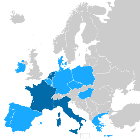
English: Map showing the countries with institutions contributing to the European Gravitational Observatory or the Virgo collaboration.
Country with institutions contributing to EGO and the Virgo collaboration
Country with institutions contributing to the Virgo collaboration |
| Date | |
| Source |
Own work Source for EGO members: https://www.ego-gw.it/about-our-mission/ Source for virgo collaboration members: https://apps.virgo-gw.eu/vmd/public/institutions |
| Author | Auguel |
Licensing edit
I, the copyright holder of this work, hereby publish it under the following license:
This file is licensed under the Creative Commons Attribution-Share Alike 4.0 International license.
- You are free:
- to share – to copy, distribute and transmit the work
- to remix – to adapt the work
- Under the following conditions:
- attribution – You must give appropriate credit, provide a link to the license, and indicate if changes were made. You may do so in any reasonable manner, but not in any way that suggests the licensor endorses you or your use.
- share alike – If you remix, transform, or build upon the material, you must distribute your contributions under the same or compatible license as the original.
File history
Click on a date/time to view the file as it appeared at that time.
| Date/Time | Thumbnail | Dimensions | User | Comment | |
|---|---|---|---|---|---|
| current | 15:09, 30 December 2022 | | 454 × 450 (479 KB) | Auguel (talk | contribs) | Reverted to version as of 16:27, 29 December 2022 (UTC) This is not a map of Europe, nor does it claim to be one |
| 17:00, 29 December 2022 |  | 454 × 450 (327 KB) | Iktsokh (talk | contribs) | Expanded to include all countries in Europe by the maximum possible definitions (since the border states of North Africa and West Asia are not on the map) | |
| 16:27, 29 December 2022 |  | 454 × 450 (479 KB) | Auguel (talk | contribs) | Reverted to version as of 18:47, 4 October 2021 (UTC) Unecessary expansion of the map | |
| 15:20, 29 December 2022 |  | 454 × 450 (327 KB) | Iktsokh (talk | contribs) | Correction of borders | |
| 18:47, 4 October 2021 |  | 454 × 450 (479 KB) | Auguel (talk | contribs) | update members | |
| 16:23, 29 July 2019 |  | 454 × 450 (479 KB) | DnaX (talk | contribs) | Belgium and Germany joined | |
| 14:06, 28 September 2017 |  | 454 × 450 (479 KB) | DnaX (talk | contribs) | Univerity of Valencia enters in the group | |
| 17:44, 27 September 2017 |  | 454 × 450 (479 KB) | Auguel (talk | contribs) | User created page with UploadWizard |
You cannot overwrite this file.
File usage on Commons
The following page uses this file:
File usage on other wikis
The following other wikis use this file:
- Usage on ar.wikipedia.org
- Usage on en.wikipedia.org
- Usage on es.wikipedia.org
- Usage on fr.wikipedia.org
- Usage on it.wikipedia.org
- Usage on ja.wikipedia.org
- Usage on ko.wikipedia.org
- Usage on pt.wikipedia.org
- Usage on ru.wikipedia.org
- Usage on uk.wikipedia.org