File:Memmingen 1737.jpg

Original file (15,180 × 11,096 pixels, file size: 58.65 MB, MIME type: image/jpeg)
Captions
Captions
| Warning | The original file is very high-resolution. It might not load properly or could cause your browser to freeze when opened at full size. |
|---|
| Title |
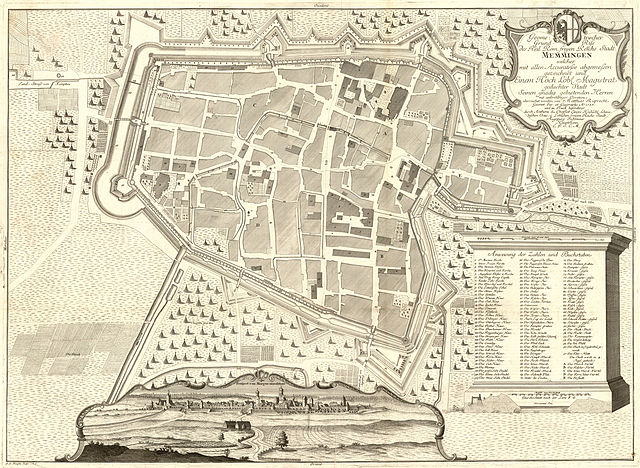
Geometrischer Grund-Riss des Heil. Röm. freyen Reichs Stadt Memmingen |
||||||||||||||||||||||
| Description |
Geometrischer Grund-Riss des Heil. Röm. freyen Reichs Stadt Memmingen welcher mit allen Accuratesse abgemessen gezeichnet und Einem Hoch Löbl. Magistrat gedachter Stadt Seinen gnädig gebietenden Herren mit unterthäniger Devotion überreichet worden / von Matthias Ruprecht Geomet. Jur. et Geographo Ao. 1737 und in Truck beförderet durch Anthoni du Chaffat Einem Hochlöbl. Schwabischen Craus u. Löblichen freyen Reichs Stadt Augspurg Ingenieur Hauptmann C.P.S.C.M. ; G. G. Ringlin Sculps. A. V. Verlag: Augspurg : durch Anthoni du Chaffat |
||||||||||||||||||||||
| Source | Kartensammlung Moll, http://mapy.mzk.cz/de/mzk03/001/061/244/2619268766/ | ||||||||||||||||||||||
| Creator |
G. G. Ringlin after Matthias Ruprecht
|
||||||||||||||||||||||
| Permission (Reusing this file) |
|
||||||||||||||||||||||
| Geotemporal data | |||||||||||||||||||||||
| Date depicted | |||||||||||||||||||||||
| Bounding box |
|
||||||||||||||||||||||
| Georeferencing | |||||||||||||||||||||||
| Bibliographic data | |||||||||||||||||||||||
| Printed by |
Antoine Du Chaffat |
||||||||||||||||||||||
| Other versions |
|
||||||||||||||||||||||

File history
Click on a date/time to view the file as it appeared at that time.
| Date/Time | Thumbnail | Dimensions | User | Comment | |
|---|---|---|---|---|---|
| current | 09:18, 14 December 2012 | | 15,180 × 11,096 (58.65 MB) | FA2010 (talk | contribs) | {{Information |Description=''Geometrischer Grund-Riss des Heil. Röm. freyen Reichs Stadt Memmingen welcher mit allen Accuratesse abgemessen gezeichnet und Einem Hoch Löbl. Magistrat gedachter Stadt Seinen gnädig gebietenden Herren mit unterthäniger... |
You cannot overwrite this file.
File usage on Commons
The following page uses this file:
File usage on other wikis
The following other wikis use this file:
- Usage on de.wikipedia.org
- Usage on fr.wikipedia.org