File:Mercator world map (physical, political, population).jpg
Size of this preview: 800 × 511 pixels. Other resolutions: 320 × 204 pixels | 640 × 408 pixels | 1,024 × 654 pixels | 1,280 × 817 pixels | 2,560 × 1,634 pixels | 6,944 × 4,432 pixels.
Original file (6,944 × 4,432 pixels, file size: 7.28 MB, MIME type: image/jpeg)
Captions
Captions
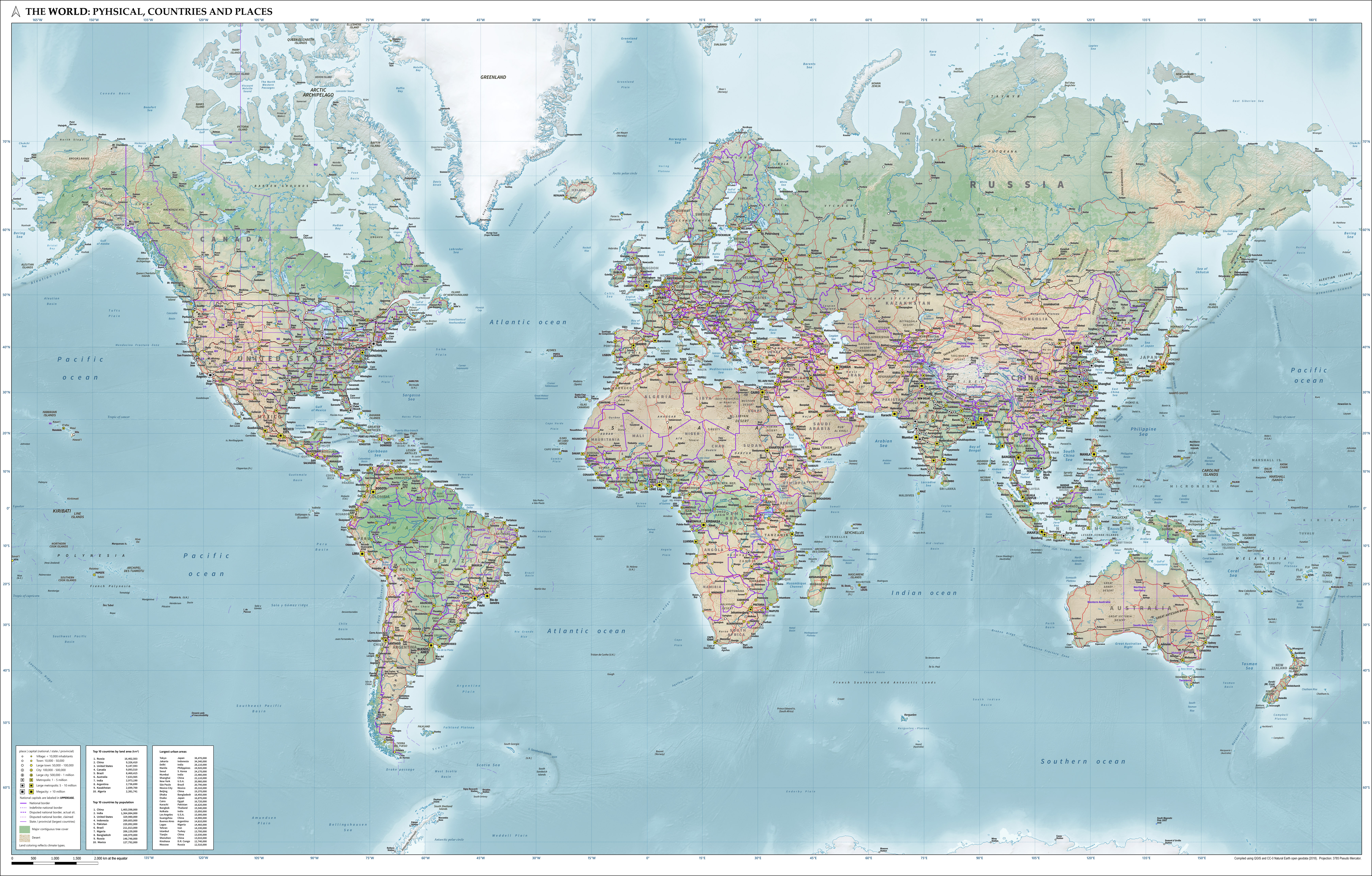
Map of the world showing physical, political and population characteristics as per 2018, in Mercator projection, based on CC-0 Natural Earth geodata.
Summary
edit.jpg&action=edit§ion=1)
| Description |
English: Combined map of the world in Pseudo Mercator projection showing physical, political and population characteristics, as per 2018. Compiled using QGIS and CC-0 Natural Earth data. Includes legend of symbols. |
| Date | |
| Source | Own work |
| Author | Janwillemvanaalst |
Licensing
edit.jpg&action=edit§ion=2)
I, the copyright holder of this work, hereby publish it under the following license:
This file is licensed under the Creative Commons Attribution 4.0 International license.
- You are free:
- to share – to copy, distribute and transmit the work
- to remix – to adapt the work
- Under the following conditions:
- attribution – You must give appropriate credit, provide a link to the license, and indicate if changes were made. You may do so in any reasonable manner, but not in any way that suggests the licensor endorses you or your use.
File history
Click on a date/time to view the file as it appeared at that time.
.jpg&dir=prev)
.jpg&offset=20200818093314)
.jpg&offset=&limit=20)
.jpg&offset=&limit=50)
.jpg&offset=&limit=100)
.jpg&offset=&limit=250)
.jpg&offset=&limit=500)
| Date/Time | Thumbnail | Dimensions | User | Comment | |
|---|---|---|---|---|---|
| current | 06:13, 4 October 2020 | | 6,944 × 4,432 (7.28 MB) | Janwillemvanaalst (talk | contribs) | Added additional regional labels, a few more places, and renamed the capital of Kazakhstan from Astana to Nur-Sultan. |
| 07:03, 19 September 2020 |  | 6,944 × 4,432 (7.23 MB) | Janwillemvanaalst (talk | contribs) | Added ocean water region labels and trench depths in m, as well as some extra mountain peaks. | |
| 06:00, 9 September 2020 |  | 6,944 × 4,432 (7.11 MB) | Janwillemvanaalst (talk | contribs) | Corrected lakes and rivers outline styling; added African regional names; added settlements in Siberia and Canada; adjusted some place labels. | |
| 06:43, 6 September 2020 |  | 6,944 × 4,432 (7.06 MB) | Janwillemvanaalst (talk | contribs) | Added regional toponyms "Yucatán", "Sahel", "Sudd", "Anatolia", "Caspian Lowland", and included some extra places, in both densely populated and sparsely populated areas. Corrected size symbol for Surabaya (Indonesia) and Changsha (China), who both crossed the 5 million urban inhabitants threshold in 2018. | |
| 06:22, 2 September 2020 |  | 6,944 × 4,432 (7.03 MB) | Janwillemvanaalst (talk | contribs) | Improved balance of place names across the different parts of the world. | |
| 05:49, 29 August 2020 |  | 6,944 × 4,432 (6.95 MB) | Janwillemvanaalst (talk | contribs) | Some further label enhancements. Corrected Malaysia. Better Aleutian area. | |
| 07:27, 27 August 2020 |  | 6,944 × 4,432 (6.94 MB) | Janwillemvanaalst (talk | contribs) | Added some additional important places in the world, plus further optimization of label placement. | |
| 06:36, 21 August 2020 |  | 6,944 × 4,432 (6.9 MB) | Janwillemvanaalst (talk | contribs) | Corrected a few typos in the source data and added some omissions (especially in Canada, Greenland, Siberia, and Antarctica). Also, placement of some labels has been improved. | |
| 05:24, 19 August 2020 |  | 6,944 × 4,432 (6.87 MB) | Janwillemvanaalst (talk | contribs) | Update of previous improvements to the original screen resolution of 6944 x 4432. | |
| 09:33, 18 August 2020 |  | 6,613 × 4,221 (6.34 MB) | Janwillemvanaalst (talk | contribs) | Corrected a few place names (such as "Ujungpandang" to "Makassar") and improved the placement of a few other labels. |
You cannot overwrite this file.
File usage on Commons
The following page uses this file:
_with_legend_(cropped).png)
File usage on other wikis
The following other wikis use this file:
- Usage on de.wikipedia.org
- Usage on guw.wiktionary.org
- Usage on hr.wikipedia.org
- Usage on nl.wikipedia.org
.jpg&oldid=677097011)