File:Merseyside and Greater Manchester Railways.svg

Size of this PNG preview of this SVG file: 800 × 327 pixels. Other resolutions: 320 × 131 pixels | 640 × 262 pixels | 1,024 × 419 pixels | 1,280 × 523 pixels | 2,560 × 1,047 pixels | 1,734 × 709 pixels.
Original file (SVG file, nominally 1,734 × 709 pixels, file size: 972 KB)
Captions
Captions
Greater Manchester Railways map

|
This file requires updating. In doing so, you could add a timestamp to the file.
|
Summary edit
| Description |
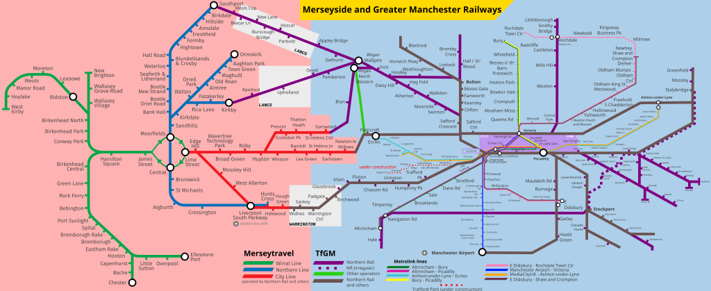
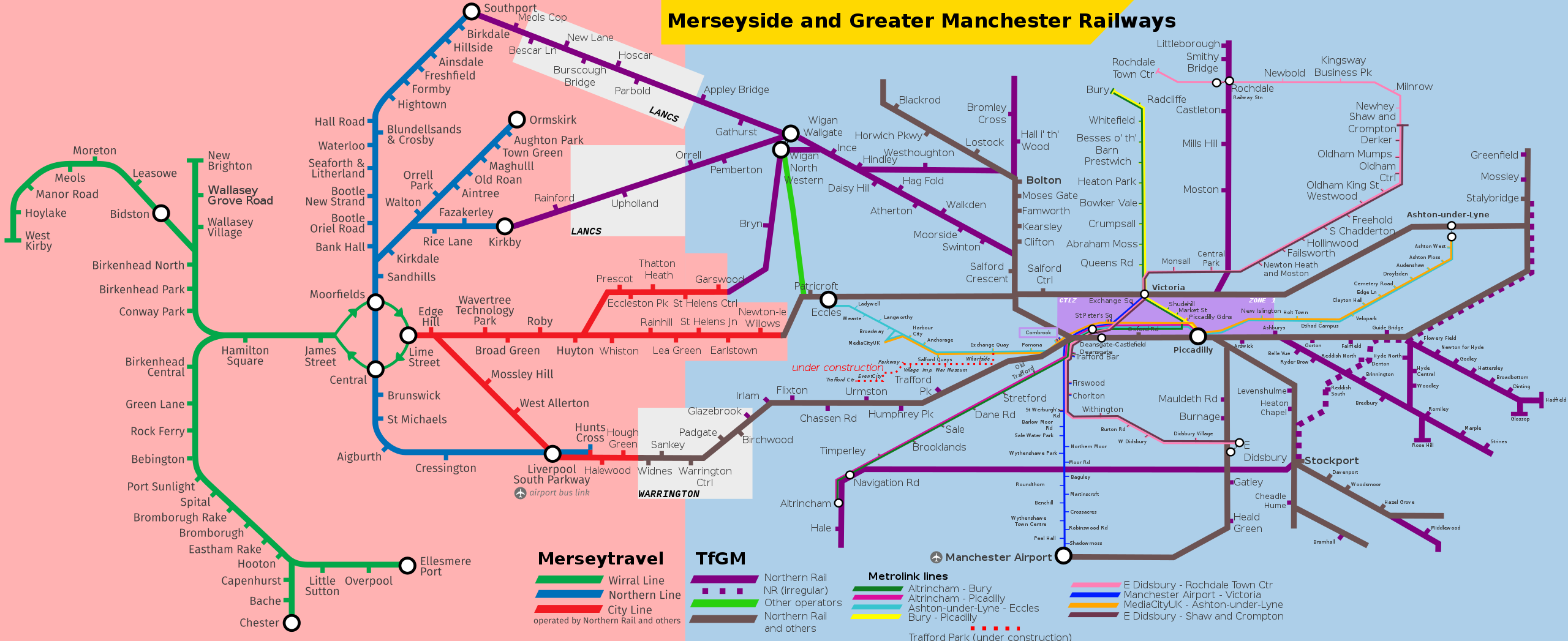
English: Map showing Merseyrail services as well as Metrolink, and heavy rail services in Greater Manchester. Uses File:Merseyrail_Map.svg by DavidArthur as well as information obtained from the Merseyrail, TfGM website and other maps uploaded to Wikimedia Commons. |
| Date | |
| Source | Own work, File:Merseyrail_Map.svg |
| Author | RaviC |
| SVG development |
Licensing edit
This file is licensed under the Creative Commons Attribution-Share Alike 4.0 International license.
- You are free:
- to share – to copy, distribute and transmit the work
- to remix – to adapt the work
- Under the following conditions:
- attribution – You must give appropriate credit, provide a link to the license, and indicate if changes were made. You may do so in any reasonable manner, but not in any way that suggests the licensor endorses you or your use.
- share alike – If you remix, transform, or build upon the material, you must distribute your contributions under the same or compatible license as the original.
File history
Click on a date/time to view the file as it appeared at that time.
| Date/Time | Thumbnail | Dimensions | User | Comment | |
|---|---|---|---|---|---|
| current | 16:54, 6 March 2019 | 1,734 × 709 (972 KB) | RaviC (talk | contribs) | fixes | |
| 02:10, 25 February 2019 | 1,625 × 665 (908 KB) | RaviC (talk | contribs) | Cornbrook zone | ||
| 01:48, 25 February 2019 | 1,625 × 665 (908 KB) | RaviC (talk | contribs) | + Zone 1 / MCR CTLZ | ||
| 17:11, 17 February 2019 | 1,625 × 665 (907 KB) | RaviC (talk | contribs) | User created page with UploadWizard |
You cannot overwrite this file.
File usage on Commons
The following 14 pages use this file:
- User:Chumwa/OgreBot/Potential transport maps/2019 February 10-18
- User:Chumwa/OgreBot/Potential transport maps/2019 February 19-28
- User:Chumwa/OgreBot/Potential transport maps/2019 March 1-10
- User:Chumwa/OgreBot/Public transport information/2019 February 10-18
- User:Chumwa/OgreBot/Public transport information/2019 February 19-28
- User:Chumwa/OgreBot/Public transport information/2019 March 1-10
- User:Chumwa/OgreBot/Transport Maps/2019 February 10-18
- User:Chumwa/OgreBot/Transport Maps/2019 February 19-28
- User:Chumwa/OgreBot/Transport Maps/2019 March 1-10
- User:Chumwa/OgreBot/Travel and communication maps/2019 February 10-18
- User:Chumwa/OgreBot/Travel and communication maps/2019 February 19-28
- User:Chumwa/OgreBot/Travel and communication maps/2019 March 1-10
- User:Mattbuck/Railways/2019 February
- User:Mattbuck/Railways/2019 March
File usage on other wikis
The following other wikis use this file:
- Usage on de.wikivoyage.org
- Usage on en.wikipedia.org
- Usage on en.wikivoyage.org
- Usage on es.wikipedia.org