File:Mesa-Mesa Grande Ruins-4.JPG

Size of this preview: 800 × 600 pixels. Other resolutions: 320 × 240 pixels | 640 × 480 pixels | 1,024 × 768 pixels | 1,280 × 960 pixels | 2,560 × 1,920 pixels | 4,320 × 3,240 pixels.
Original file (4,320 × 3,240 pixels, file size: 3.08 MB, MIME type: image/jpeg)
Captions
Captions
Add a one-line explanation of what this file represents
Summary
edit
| Description |
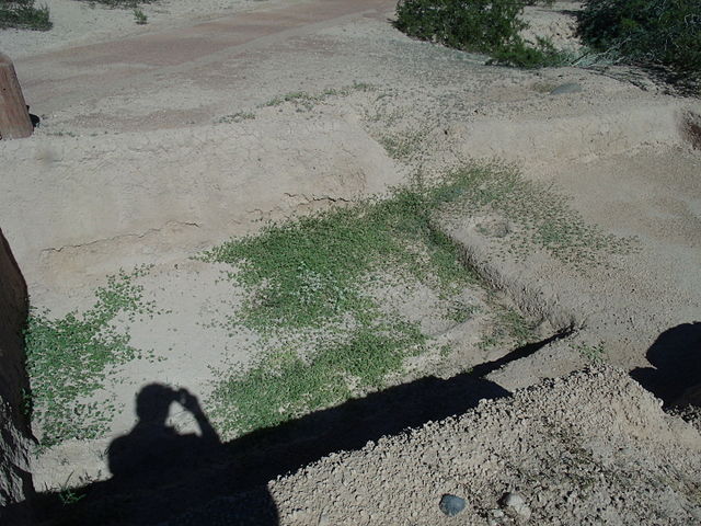
English: One of the two largest networks of irrigation canals created in the prehistoric Americans by the Hohokams. It is located in the Mesa Grande Cultural Park at 1000 N. Date St. The Mesa Grande Cultural Park was listed in the National Register of Historic Places in November 21, 1978, reference number 78000549. |
| Date | (UTC) |
| Source |
Transferred from en.wikipedia to Commons. (Original text: I (Tony the Marine (talk)) created this work entirely by myself.) |
| Author | Tony the Marine (talk) |
Licensing
edit
Marine 69-71 at English Wikipedia, the copyright holder of this work, hereby publishes it under the following licenses:
This file is licensed under the Creative Commons Attribution-Share Alike 3.0 Unported license.
Attribution: Marine 69-71 at English Wikipedia
- You are free:
- to share – to copy, distribute and transmit the work
- to remix – to adapt the work
- Under the following conditions:
- attribution – You must give appropriate credit, provide a link to the license, and indicate if changes were made. You may do so in any reasonable manner, but not in any way that suggests the licensor endorses you or your use.
- share alike – If you remix, transform, or build upon the material, you must distribute your contributions under the same or compatible license as the original.

|
Permission is granted to copy, distribute and/or modify this document under the terms of the GNU Free Documentation License, Version 1.2 or any later version published by the Free Software Foundation; with no Invariant Sections, no Front-Cover Texts, and no Back-Cover Texts. A copy of the license is included in the section entitled GNU Free Documentation License. |
You may select the license of your choice.
Original upload log
edit
The original description page was here. All following user names refer to en.wikipedia.
| Date/Time | Dimensions | User | Comment |
|---|---|---|---|
| 2014-11-07 00:35 | 4320×3240× (3230990 bytes) | Marine 69-71 | {{Information |Description =One of the two largest networks of irrigation canals created in the prehistoric Americans by the Hohokams. It is located in the ''' Mesa Grande Cultural Park ''' at 1000 N. Date St. The Mesa Grande Cultural Park was list... |
File history
Click on a date/time to view the file as it appeared at that time.
| Date/Time | Thumbnail | Dimensions | User | Comment | |
|---|---|---|---|---|---|
| current | 03:58, 8 March 2016 | | 4,320 × 3,240 (3.08 MB) | FastilyClone (talk | contribs) | Transferred from enwp |
You cannot overwrite this file.
File usage on Commons
There are no pages that use this file.
File usage on other wikis
The following other wikis use this file:
- Usage on en.wikipedia.org