File:Metrication.svg

Size of this PNG preview of this SVG file: 800 × 411 pixels. Other resolutions: 320 × 164 pixels | 640 × 329 pixels | 1,024 × 526 pixels | 1,280 × 657 pixels | 2,560 × 1,314 pixels.
Original file (SVG file, nominally 2,560 × 1,314 pixels, file size: 1.13 MB)
Captions
Captions
Add a one-line explanation of what this file represents
Summary
edit| Description |
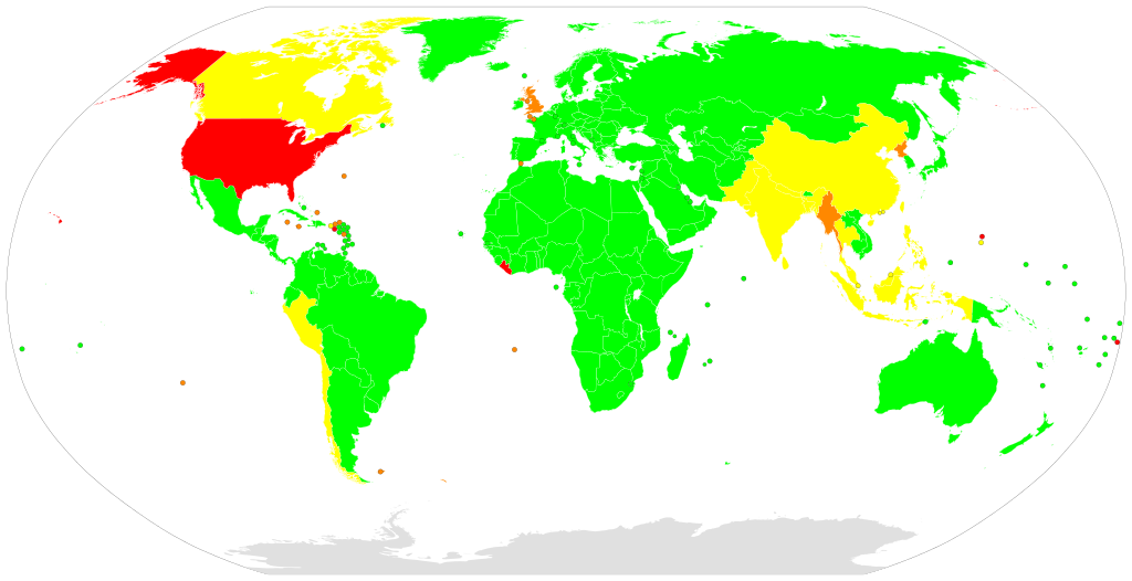
English: Map of countries according to their metrication status, based on Metrication article (English Wikipedia).[1][2][3]
Complete Almost complete Partially complete Little adoption
|
| Date |
|
| Source |
Own work |
| Author | Carnby |
| Other versions |
|
| SVG development |


.svg)
Licensing
edit
I, the copyright holder of this work, hereby publish it under the following license:
| This file is made available under the Creative Commons CC0 1.0 Universal Public Domain Dedication. | |
| The person who associated a work with this deed has dedicated the work to the public domain by waiving all of their rights to the work worldwide under copyright law, including all related and neighboring rights, to the extent allowed by law. You can copy, modify, distribute and perform the work, even for commercial purposes, all without asking permission.
|
File history
Click on a date/time to view the file as it appeared at that time.
| Date/Time | Thumbnail | Dimensions | User | Comment | |
|---|---|---|---|---|---|
| current | 16:22, 19 October 2019 | | 2,560 × 1,314 (1.13 MB) | A11w1ss3nd (talk | contribs) | changed orange color to RGB: #ff8800 (=#F80) as used in the legend (better distinguishable from the red hue) |
| 21:52, 17 July 2019 |  | 2,560 × 1,314 (1.06 MB) | Carnby (talk | contribs) | Updated India, Pakistan, Bangladesh, Nepal, Malaysia, Singapore, Brunei | |
| 18:30, 2 October 2018 |  | 2,560 × 1,314 (1.06 MB) | Carnby (talk | contribs) | Puerto Rico, Guam (metricated before U.S. rule and mostly metric) | |
| 22:31, 16 September 2018 |  | 2,560 × 1,314 (1.06 MB) | Carnby (talk | contribs) | Updated map according to en.wiki article; human-editable plain text format; if you disagree with my edit, please write me before reverting it | |
| 00:58, 1 December 2016 |  | 863 × 443 (2.54 MB) | Thespaceface (talk | contribs) | Changes upon request of 31.200.8.145 | |
| 21:28, 16 November 2016 |  | 863 × 443 (2.54 MB) | Thespaceface (talk | contribs) | more fixes | |
| 20:31, 31 October 2016 |  | 863 × 443 (2.52 MB) | Thespaceface (talk | contribs) | fix | |
| 20:28, 31 October 2016 |  | 863 × 443 (2.49 MB) | Thespaceface (talk | contribs) | better version | |
| 19:07, 6 January 2016 |  | 1,500 × 775 (360 KB) | Thespaceface (talk | contribs) | User created page with UploadWizard |
You cannot overwrite this file.
File usage on Commons
The following 9 pages use this file:
File usage on other wikis
The following other wikis use this file:
- Usage on de.wikipedia.org
- Usage on en.wikipedia.org
- Usage on es.wikipedia.org
- Usage on fr.wikipedia.org
- Usage on nl.wikipedia.org
- Usage on zh.wikipedia.org