File:Mexico's Territorial Evolution.png

Size of this preview: 659 × 599 pixels. Other resolutions: 264 × 240 pixels | 528 × 480 pixels | 844 × 768 pixels | 1,126 × 1,024 pixels | 1,669 × 1,518 pixels.
Original file (1,669 × 1,518 pixels, file size: 113 KB, MIME type: image/png)
Captions
Captions
Add a one-line explanation of what this file represents
Summary
edit
| Description |
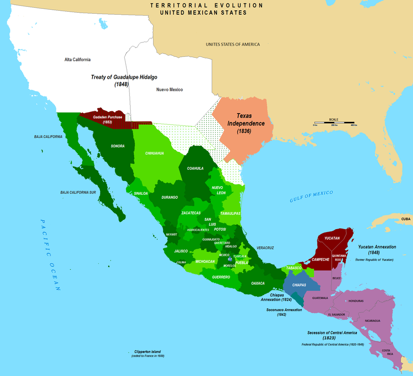
English: Territorial Evolution of Mexico since 1821 to 2009 |
| Date | |
| Source | Own work |
| Author | Hpav7 |

|
This historical map image could be re-created using vector graphics as an SVG file. This has several advantages; see Commons:Media for cleanup for more information. If an SVG form of this image is available, please upload it and afterwards replace this template with
{{vector version available|new image name}}.
It is recommended to name the SVG file “Mexico's Territorial Evolution.svg”—then the template Vector version available (or Vva) does not need the new image name parameter. |
Licensing
edit
| I, the copyright holder of this work, release this work into the public domain. This applies worldwide. In some countries this may not be legally possible; if so: I grant anyone the right to use this work for any purpose, without any conditions, unless such conditions are required by law. |
File history
Click on a date/time to view the file as it appeared at that time.
| Date/Time | Thumbnail | Dimensions | User | Comment | |
|---|---|---|---|---|---|
| current | 23:09, 14 September 2019 | | 1,669 × 1,518 (113 KB) | Urbanuntil (talk | contribs) | checking that is software error |
| 23:01, 14 September 2019 |  | 1,669 × 1,518 (132 KB) | Urbanuntil (talk | contribs) | - | |
| 22:54, 14 September 2019 |  | 1,669 × 1,518 (145 KB) | Urbanuntil (talk | contribs) | checking color mistake's origin | |
| 22:46, 14 September 2019 |  | 1,669 × 1,518 (132 KB) | Urbanuntil (talk | contribs) | grammar | |
| 03:47, 3 April 2010 |  | 1,669 × 1,518 (147 KB) | Hpav7 (talk | contribs) | Various | |
| 10:54, 4 December 2009 |  | 1,669 × 1,518 (147 KB) | Hpav7 (talk | contribs) | correccion de los margenes y limites fronterizos correction of the margins and border boundaries | |
| 03:29, 19 July 2009 |  | 1,669 × 1,518 (147 KB) | Hpav7 (talk | contribs) | {{Information |Description={{en|1=Territorial Evolution of Mexico since 1821 to 2009}} |Source=Own work by uploader |Author=Hpav7 |Date=2009-07-18 |Permission= |other_versions= }} Category:Maps of Mexico Category:Map of Mexico [[Ca |
You cannot overwrite this file.
File usage on Commons
There are no pages that use this file.
File usage on other wikis
The following other wikis use this file:
- Usage on af.wikipedia.org
- Usage on ar.wikipedia.org
- Usage on arz.wikipedia.org
- Usage on be.wikipedia.org
- Usage on cs.wikipedia.org
- Usage on de.wikipedia.org
- Usage on en.wikipedia.org
- Usage on es.wikipedia.org
- Usage on eu.wikipedia.org
- Usage on fr.wikipedia.org
- Usage on ia.wikipedia.org
- Usage on la.wikipedia.org
- Usage on mk.wikipedia.org
- Usage on pl.wikipedia.org
- Usage on pt.wikipedia.org
- Usage on sh.wikipedia.org
- Usage on sr.wikipedia.org
- Usage on sw.wikipedia.org
- Usage on te.wikipedia.org
- Usage on www.wikidata.org