File:Mexico Guerrero Florencio Villarreal.svg

Size of this PNG preview of this SVG file: 800 × 503 pixels. Other resolutions: 320 × 201 pixels | 640 × 403 pixels | 1,024 × 644 pixels | 1,280 × 805 pixels | 2,560 × 1,610 pixels | 3,993 × 2,512 pixels.
Original file (SVG file, nominally 3,993 × 2,512 pixels, file size: 1.18 MB)
Captions
Captions
Add a one-line explanation of what this file represents
Summary edit
| Description |
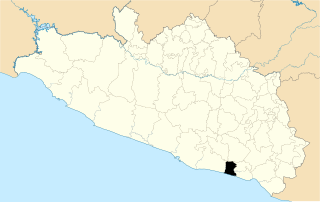
English: Map of the municipality of Florencio Villarreal in the mexican state of Guerrero
Español: Mapa del municipio de Florencio Villarreal en el estado mexicano de Guerrero |
| Date | |
| Source |
This file was derived from: Mexico Guerrero location map.svg |
| Author |
This W3C-unspecified vector image was created with Inkscape .
| This is a retouched picture, which means that it has been digitally altered from its original version. The original can be viewed here: Mexico Guerrero location map.svg:
|
Licensing edit
This file is licensed under the Creative Commons Attribution 3.0 Unported license.
- You are free:
- to share – to copy, distribute and transmit the work
- to remix – to adapt the work
- Under the following conditions:
- attribution – You must give appropriate credit, provide a link to the license, and indicate if changes were made. You may do so in any reasonable manner, but not in any way that suggests the licensor endorses you or your use.
File history
Click on a date/time to view the file as it appeared at that time.
| Date/Time | Thumbnail | Dimensions | User | Comment | |
|---|---|---|---|---|---|
| current | 13:36, 15 June 2017 | | 3,993 × 2,512 (1.18 MB) | MikSed (talk | contribs) | == {{int:filedesc}} == {{Information |Description={{en|1=Map of the municipality of Florencio Villarreal in the mexican state of Guerrero}} {{es|1=Mapa del municipio de Florencio Villarreal en el estado mexicano de Guerrero}} |Source={{Derived from|Mex... |
You cannot overwrite this file.
File usage on Commons
There are no pages that use this file.
File usage on other wikis
The following other wikis use this file:
- Usage on it.wikipedia.org
- Usage on ru.wikipedia.org