File:Michigan 185 map.png

Size of this preview: 800 × 450 pixels. Other resolutions: 320 × 180 pixels | 640 × 360 pixels | 1,024 × 575 pixels | 1,280 × 719 pixels | 2,205 × 1,239 pixels.
Original file (2,205 × 1,239 pixels, file size: 94 KB, MIME type: image/png)
Captions
Captions
Add a one-line explanation of what this file represents
| Description |
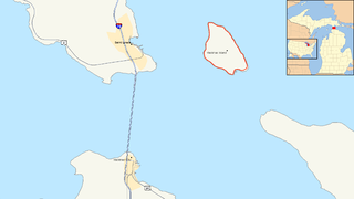
Map of the Straits of Mackinac showing M-185 |
| Date | |
| Source | Own work using MiGDL - Center for Geographic Information - Geographic Data Library. Michigan Department of Information Technology (May 2007). Archived from the original on 2011-07-17. Retrieved on 2011-11-09 Retrieved on July 18, 2006. |
| Author | Nick Nolte |
| Permission (Reusing this file) |
Own work, all rights released (Public domain) |
| This is a retouched picture, which means that it has been digitally altered from its original version. Modifications: Added inset using File:Michigan Locator Map with US.PNG and colorized Lakes Michigan and Huron blue. Modifications made by Imzadi1979.
|
I, the copyright holder of this work, hereby publish it under the following license:
| This file is made available under the Creative Commons CC0 1.0 Universal Public Domain Dedication. | |
| The person who associated a work with this deed has dedicated the work to the public domain by waiving all of their rights to the work worldwide under copyright law, including all related and neighboring rights, to the extent allowed by law. You can copy, modify, distribute and perform the work, even for commercial purposes, all without asking permission.
|
File history
Click on a date/time to view the file as it appeared at that time.
| Date/Time | Thumbnail | Dimensions | User | Comment | |
|---|---|---|---|---|---|
| current | 01:40, 9 November 2011 | | 2,205 × 1,239 (94 KB) | Imzadi1979 (talk | contribs) | colored Lakes Michigan and Huron blue and added a locator inset |
| 05:10, 22 July 2006 |  | 2,205 × 1,239 (71 KB) | Stratosphere (talk | contribs) | {{Information| |Description=Map of Michigan State Route 185 |Source=Own Work |Date=July 21, 2006 |Author=Nick Nolte |Permission=Own work, all rights released (Public domain) |other_versions= }} {{PD-self}} [[Category:Michigan Hig |
You cannot overwrite this file.
File usage on Commons
The following 2 pages use this file:
File usage on other wikis
The following other wikis use this file:
- Usage on en.wikipedia.org
- Usage on fr.wikipedia.org
- Usage on ru.wikipedia.org
- Usage on simple.wikipedia.org
- Usage on www.wikidata.org
- Usage on zh-min-nan.wikipedia.org