File:Miki city area in1974.JPG
No higher resolution available.
Miki_city_area_in1974.JPG (438 × 403 pixels, file size: 92 KB, MIME type: image/jpeg)
Captions
Captions
Add a one-line explanation of what this file represents
Summary edit
| Description |
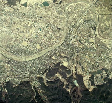
English: Miki city area in 1974
日本語: 三木市街地 (1974年度) |
| Date | |
| Source | 国土画像情報(カラー空中写真) 国土交通省 |
| Author | 国土交通省 改変 mti |
Licensing edit

|
The copyright holder of this file, the Ministry of Land, Infrastructure, Transport and Tourism of Japan, allows anyone to use it for any purpose, provided that the copyright holder is properly attributed. Redistribution, derivative work, commercial use, and all other use is permitted. |
Attribution:
Copyright © National Land Image Information (Color Aerial Photographs), Ministry of Land, Infrastructure, Transport and Tourism
|
 |
This image is copyrighted by the Ministry of Land, Infrastructure, Transport and Tourism of Japan. For terms of use, see the stipulation to use of National Land Information (in Japanese) and message from MLIT (in Japanese and English). When you display this image on an article, include the following phrase in the description: "Made based on National Land Image Information (Color Aerial Photographs), Ministry of Land, Infrastructure, Transport and Tourism".
|
File history
Click on a date/time to view the file as it appeared at that time.
| Date/Time | Thumbnail | Dimensions | User | Comment | |
|---|---|---|---|---|---|
| current | 13:01, 14 February 2011 | | 438 × 403 (92 KB) | Mti (talk | contribs) | {{Information |Description ={{en|1=Miki city area in 1974}} {{ja|1=三木市街地 (1974年度)}} |Source =[http://w3land.mlit.go.jp/WebGIS/ 国土画像情報(カラー空中写真)] 国土交通省 |Author =国土交通省 改 |
You cannot overwrite this file.
File usage on Commons
The following page uses this file: