File:Milestone opposite the Armytage Arms, Clifton - geograph.org.uk - 679915.jpg
No higher resolution available.
Milestone_opposite_the_Armytage_Arms,_Clifton_-_geograph.org.uk_-_679915.jpg (640 × 479 pixels, file size: 82 KB, MIME type: image/jpeg)
Captions
Captions
Add a one-line explanation of what this file represents
Summary
edit
| Description |
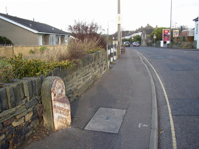
English: Milestone opposite the Armytage Arms, Clifton This is at the junction of Clifton Common, Highmoor Lane (both A643) and Towngate. When W B Crump wrote 'Huddersfield highways down the ages' in 1949 there was a guidestone, dates 1787, at this junction. The directions are: Leeds 11 miles, Elland 4 miles and Barnsley 20 miles. It is interesting that the road through Clifton village led to Barnsley. The route would be via Cooper Bridge, Colne Bridge, Grange Moor and Flockton. |
| Date | |
| Source | From geograph.org.uk |
| Author | Humphrey Bolton |
| Attribution (required by the license) | Humphrey Bolton / Milestone opposite the Armytage Arms, Clifton / |
| Camera location | | View this and other nearby images on: OpenStreetMap |
|---|
_heading:45.00&language=en)
| Object location | | View this and other nearby images on: OpenStreetMap |
|---|
_heading:45.00&language=en)
Licensing
edit

|
This image was taken from the Geograph project collection. See this photograph's page on the Geograph website for the photographer's contact details. The copyright on this image is owned by Humphrey Bolton and is licensed for reuse under the Creative Commons Attribution-ShareAlike 2.0 license.
|
This file is licensed under the Creative Commons Attribution-Share Alike 2.0 Generic license.
Attribution: Humphrey Bolton
- You are free:
- to share – to copy, distribute and transmit the work
- to remix – to adapt the work
- Under the following conditions:
- attribution – You must give appropriate credit, provide a link to the license, and indicate if changes were made. You may do so in any reasonable manner, but not in any way that suggests the licensor endorses you or your use.
- share alike – If you remix, transform, or build upon the material, you must distribute your contributions under the same or compatible license as the original.
File history
Click on a date/time to view the file as it appeared at that time.
| Date/Time | Thumbnail | Dimensions | User | Comment | |
|---|---|---|---|---|---|
| current | 22:40, 7 February 2011 | | 640 × 479 (82 KB) | GeographBot (talk | contribs) | == {{int:filedesc}} == {{Information |description={{en|1=Milestone opposite the Armytage Arms, Clifton This is at the junction of Clifton Common, Highmoor Lane (both A643) and Towngate. When W B Crump wrote 'Huddersfield highways down the ages' in 1949 th |
You cannot overwrite this file.
File usage on Commons
There are no pages that use this file.