File:Military administration Belgium Northern France.png
Size of this preview: 800 × 358 pixels. Other resolutions: 320 × 143 pixels | 1,000 × 448 pixels.
Original file (1,000 × 448 pixels, file size: 142 KB, MIME type: image/png)
Captions
Captions
Add a one-line explanation of what this file represents
Summary
edit
| Description |
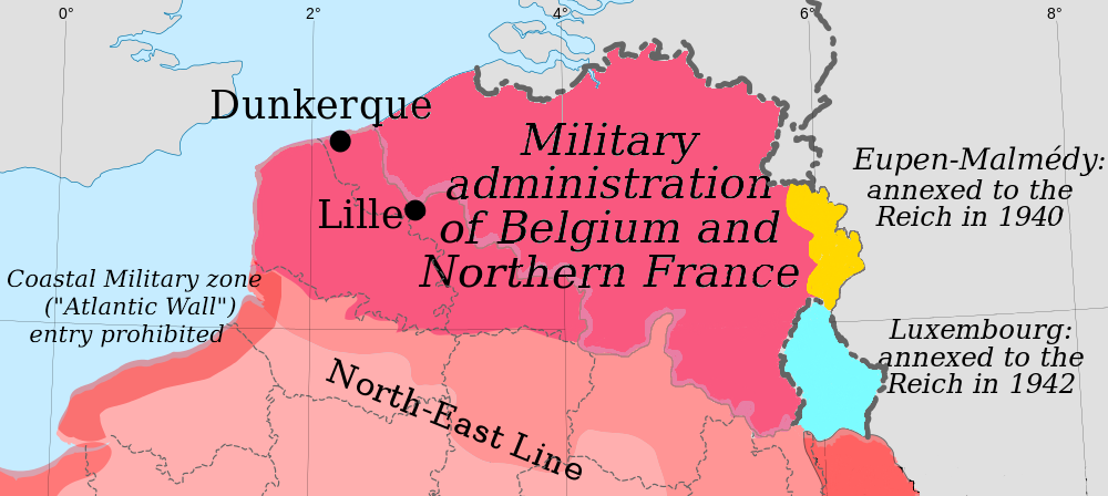
English: Map of the German military administration of Belgium and Northern France. |
| Date | |
| Source | self-made map, derived from File:France_map_Lambert-93_with_regions_and_departments-occupation.svg |
| Author | Original creators were Eric Gaba (Sting) for the original blank map and Rama for the zones. |
Licensing
edit
| I, the copyright holder of this work, release this work into the public domain. This applies worldwide. In some countries this may not be legally possible; if so: I grant anyone the right to use this work for any purpose, without any conditions, unless such conditions are required by law. |
File history
Click on a date/time to view the file as it appeared at that time.
| Date/Time | Thumbnail | Dimensions | User | Comment | |
|---|---|---|---|---|---|
| current | 11:08, 25 May 2014 | | 1,000 × 448 (142 KB) | Victor falk~commonswiki (talk | contribs) | based on File:France map Lambert-93 with regions and departments-occupation Belgium.png |
| 22:36, 29 October 2010 |  | 290 × 139 (26 KB) | Morgan Hauser (talk | contribs) | {{Information |Description={{en|1=Map of the German military administration of Belgium and Northern France.}} |Source=self-made map, derived from File:France_map_Lambert-93_with_regions_and_departments-occupation.svg |Author=Original creators were Er |
You cannot overwrite this file.
File usage on Commons
There are no pages that use this file.
File usage on other wikis
The following other wikis use this file:
- Usage on bs.wikipedia.org
- Usage on de.wikipedia.org
- Usage on fr.wikipedia.org
- Usage on nl.wikipedia.org
- Usage on no.wikipedia.org
- Usage on sh.wikipedia.org
- Usage on sr.wikipedia.org