File:Misak-i milli.png

Size of this preview: 800 × 493 pixels. Other resolutions: 320 × 197 pixels | 640 × 395 pixels | 1,024 × 631 pixels | 1,474 × 909 pixels.
Original file (1,474 × 909 pixels, file size: 204 KB, MIME type: image/png)
Captions
Captions
Add a one-line explanation of what this file represents
Summary edit
| Description |
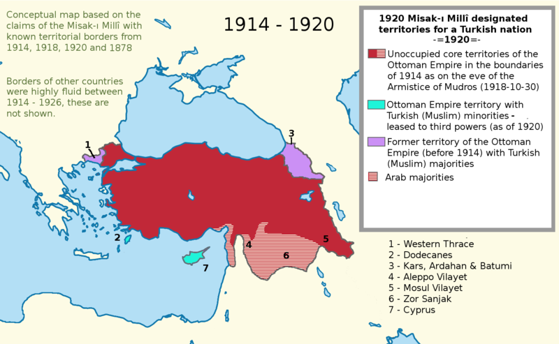
English: I worked more on the proposal map and I also added the current territories. This map shows the goal of the Turkish side. I used a Wikipedia map while I was working on this project. It is called "LocationTurkey2". --Please help me erasing the older one (Misak-ı_milli.PNG)--
Turkish variation: File:Misak-i_milli_tr.png |
| Date | 23 February 2007 (original upload date) |
| Source | Transferred from en.wikipedia to Commons. |
| Author | Deliogul at English Wikipedia |
Licensing edit
Deliogul at the English-language Wikipedia, the copyright holder of this work, hereby publishes it under the following license:

|
Permission is granted to copy, distribute and/or modify this document under the terms of the GNU Free Documentation License, Version 1.2 or any later version published by the Free Software Foundation; with no Invariant Sections, no Front-Cover Texts, and no Back-Cover Texts. A copy of the license is included in the section entitled GNU Free Documentation License. |
| This file is licensed under the Creative Commons Attribution-Share Alike 3.0 Unported license. | ||
| Attribution: Deliogul | ||
| ||
| This licensing tag was added to this file as part of the GFDL licensing update. |
Original upload log edit
The original description page was here. All following user names refer to en.wikipedia.
- 2007-02-23 16:09 Deliogul 610×166×8 (27404 bytes) I worked more on the proposal map and I also added the current territories. This map shows the goal of the Turkish side. I used a Wikipedia map while I was working on this project. It is called "LocationTurkey2". --Please help me erasing the older one (Mi
File history
Click on a date/time to view the file as it appeared at that time.
| Date/Time | Thumbnail | Dimensions | User | Comment | |
|---|---|---|---|---|---|
| current | 21:43, 30 November 2016 | | 1,474 × 909 (204 KB) | ScienceDawns (talk | contribs) | Removed redundant information, weasel word, cropped to part a until reliable encyclopedic sources can be provided linking the current situation to the Misak-ı Millî decisions. |
| 20:48, 11 November 2016 |  | 1,474 × 1,826 (508 KB) | Metrancya (talk | contribs) | Complete replacement of the original file - the accuracy of the old file was disputed and the content of the old file did not match the text of the Misak-ı millî. The new file follows the Misak-ı millî word-by-word and outlines the original designa... | |
| 22:47, 9 April 2008 | 610 × 166 (27 KB) | KureCewlik81 (talk | contribs) | {{Information |Description={{en|I worked more on the proposal map and I also added the current territories. This map shows the goal of the Turkish side. I used a Wikipedia map while I was working on this project. It is called "LocationTurkey2". --Please h |
You cannot overwrite this file.
File usage on Commons
The following page uses this file:
File usage on other wikis
The following other wikis use this file:
- Usage on ar.wikipedia.org
- Usage on arz.wikipedia.org
- Usage on azb.wikipedia.org
- Usage on az.wikipedia.org
- Usage on ca.wikipedia.org
- Usage on de.wikipedia.org
- Usage on el.wikipedia.org
- Usage on en.wikipedia.org
- Usage on he.wikipedia.org
- Usage on hu.wikipedia.org
- Usage on hy.wikipedia.org
- Usage on it.wikipedia.org
- Usage on mk.wikipedia.org
- Usage on nl.wikipedia.org
- Usage on pnb.wikipedia.org
- Usage on pt.wikipedia.org
- Usage on ru.wikipedia.org
- Usage on tr.wikipedia.org
- Usage on uk.wikipedia.org
- Usage on ur.wikipedia.org
- Usage on www.wikidata.org