File:Mississippi River old Lock and Dam number 26.jpg

Size of this preview: 800 × 533 pixels. Other resolutions: 320 × 213 pixels | 640 × 427 pixels | 1,024 × 683 pixels | 1,500 × 1,000 pixels.
Original file (1,500 × 1,000 pixels, file size: 314 KB, MIME type: image/jpeg)
Captions
Captions
Add a one-line explanation of what this file represents
| Description |
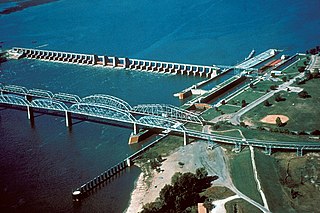
Aerial view of old Lock and Dam 26 — on the Mississippi River in Missouri and Alton, Illinois.
|
|||
| Date | before July 1994 | |||
| Source |
US Army Corps of Engineers Digital Visual Library (DVL) |
|||
| Author | US Army Corps of Engineers, Unknown Photographer | |||
| Permission (Reusing this file) |
|
| Object location | | View this and other nearby images on: OpenStreetMap |
|---|
File history
Click on a date/time to view the file as it appeared at that time.
| Date/Time | Thumbnail | Dimensions | User | Comment | |
|---|---|---|---|---|---|
| current | 20:24, 16 February 2007 | | 1,500 × 1,000 (314 KB) | Dual Freq (talk | contribs) | {{Information | Description = Aerial view of old Lock and Dam 26, Mississippi River, Alton, Illinois. Caption from source page is incorrect and says this is L&D 19, but it is actually 26, now demolished. | Source = [http://images.usace.army.mil/mai |
You cannot overwrite this file.
File usage on Commons
The following page uses this file:
File usage on other wikis
The following other wikis use this file:
- Usage on arz.wikipedia.org
- Usage on de.wikipedia.org
- Usage on en.wikipedia.org
- Usage on www.wikidata.org