File:Mississippi counties Katrina severe damage map.png
Original file (500 × 805 pixels, file size: 38 KB, MIME type: image/png)
Captions
Captions
Summary
edit
| Description |
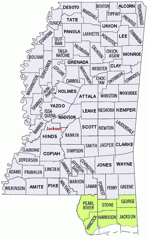
English: Disaster map of the state of Mississippi showing borders and names of the counties, with highlight coloring of the counties most affected. |
| Date | |
| Source | Source (Wikipedia): File:Mississippi counties map.png (converted to GIF format, with white background trimmed). |
| Author | U.S. Census Bureau/Wikid77 |
| Other versions |
|
Licensing
edit
This image or file is a work of a United States Census Bureau employee, taken or made as part of that person's official duties. As a work of the U.S. federal government, the image is in the public domain.
|
 |
| This work has been released into the public domain by its author, Wikid77 at English Wikipedia. This applies worldwide. In some countries this may not be legally possible; if so: Wikid77 grants anyone the right to use this work for any purpose, without any conditions, unless such conditions are required by law. |
Original upload log
edit
| Date/Time | Dimensions | User | Comment |
|---|---|---|---|
| 2007-03-25 04:13 | 500×805× (39253 bytes) | PNG crusade bot | Disaster map of the state of [[Mississippi]] showing borders and names of the counties, with highlight coloring of the counties most affected. Source (Wikipedia): [[:Image:Mississippi counties map.png]] (converted to [[GIF]] format, with white |
Previous file history
edit
The PNG crusade bot automatically converted this image to the more efficient PNG format. The image was previously uploaded as "Mississippi counties disaster map narrow.gif".
17:09:05, 25 February 2007 . . Wikid77 (Talk | Contribs) . . 500x805 (52,665 bytes) (Edited to clarify several county names.)
12:38:36, 25 February 2007 . . Wikid77 (Talk | Contribs) . . 500x805 (52,656 bytes) (Enlarged many county names from previous version.)
06:25:41, 25 February 2007 . . Wikid77 (Talk | Contribs) . . 500x805 (54,276 bytes) (Disaster map of the state of [[:en:Mississippi|]] showing borders and names of the counties, with highlight coloring of the counties most affected. Source (Wikipedia): [[:en::Image:Mississippi counties map.png|]] (converted to [[:en:GIF|]] format, with white background)
File history
Click on a date/time to view the file as it appeared at that time.
| Date/Time | Thumbnail | Dimensions | User | Comment | |
|---|---|---|---|---|---|
| current | 18:01, 1 March 2017 | | 500 × 805 (38 KB) | Innotata (talk | contribs) | Transferred from en.wikipedia |
You cannot overwrite this file.
File usage on Commons
There are no pages that use this file.
File usage on other wikis
The following other wikis use this file:
- Usage on en.wikipedia.org